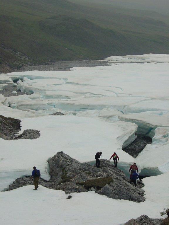

A river icing on a small unnamed river that drains into Galbraith Lake, Alaska, which is in the Atigun River basin and was a major base camp location for the construction of the Trans-Alaska Pipeline connecting the Arctic Ocean to Valdez, Alaska. The people in this photo are researchers and students associated with Toolik Field Station.
Credit: Jay Zarnetske
Climate change is causing thick ice deposits that form along Arctic rivers to melt nearly a month earlier than they did 15 years ago, a new study finds.
River icings form when Arctic groundwater reaches the surface and solidifies on top of frozen rivers. They grow throughout the winter until river valleys are choked with ice. Some river icings have grown to more than 10 square kilometers (4 square miles) in area – roughly three times the size of New York's Central Park – and can be more than 10 meters (33 feet) thick.
In the past, river icings have melted out around mid-July, on average. But a new study measuring the extent of river icings in the U.S. and Canadian Arctic shows most river icings disappeared 26 days earlier, on average, in 2015 than they did in 2000, melting around mid-June. In addition, the study found most icings that don't completely melt every summer were significantly smaller in 2015 than they were in 2000. Watch a video of river icings here.
“This is the first clear evidence that this important component of Arctic river systems – which we didn't know was changing – is changing and it's changing rapidly,” said Tamlin Pavelsky, a hydrologist at the University of North Carolina Chapel Hill and lead author of the new study published in Geophysical Research Letters, a journal of the American Geophysical Union.
Scientists have studied the effects of climate change on other types of Arctic ice like glaciers and sea ice, but until now no study has systematically looked at whether river icings are changing in response to a warming climate, according to the authors.
Although the decline in river icings is likely a result of climate change, the authors are unsure whether the decline in river icings is a direct result of rising temperatures or if climate change is altering how rivers and groundwater interact.
“While glaciers tell us about climate in the mountains and sea ice tells us about sea-atmosphere interactions, the processes that control river icing may offer great insight into how groundwater and surface waters are connected in the Arctic and how our headwaters will be connected to the ocean in the future,” said Jay Zarnetske, a hydrologist at Michigan State University in East Lansing, Michigan, and co-author of the study.
The decline in river icings is remarkably rapid and if it continues, it could have huge impacts on Arctic river ecosystems, Pavelsky said.
River icings are found all over the Arctic and create wide channels that are important habitats for animals and fish. So much water is tied up in river icings that when they melt in summer, usually in July and August, they keep rivers flowing that might otherwise dry up, providing important freshwater habitat for fish and other animals, he said.
Disappearing ice
The idea to study river icings came to Pavelsky in 2013 during a flight to northern Alaska for a recreational canoe trip. The pilot of the small plane, who had flown in the area for more than 30 years, said he noticed river icings were melting earlier in the season and the timing was becoming more unpredictable. River icings pack down the gravel on riverbeds and pilots use them as makeshift runways.
“My scientist antenna went right up,” Pavelsky said. “I said 'Hey, I think I know how to look at that.”
When Pavelsky returned from the trip, he downloaded data from the moderate-resolution imaging spectroradiometer (MODIS) aboard the NASA Terra satellite, which takes daily images of Earth. Pavelsky and Zarnetske then analyzed daily MODIS images of the U.S. and Canadian Arctic from 2000 to 2015, wondering if they could see evidence of changes to the ice that Pavelsky's pilot had described.
They could. Pavelsky and Zarnetske detected 147 river icings using the MODIS data and found that of those, 84 are either becoming smaller or disappearing earlier in the season. The rest were unchanged. None of the river icings they analyzed grew or persisted later in the season.
The minimum area of ice they measured also shrank considerably over the study period. In 2000, Pavelsky and Zarnetske measured a minimum ice area of 80 square kilometers (30 square miles) – roughly half the area of Washington, D.C. By 2010, that number had dwindled to just 4 square kilometers (2 square miles) – smaller than San Diego's Balboa Park. By 2015, the ice had rebounded slightly, with a minimum area of about 7 square kilometers (3 square miles).
“I think it's a really important study, as another example of the types of changes we're seeing in the Arctic landscape,” said Ken Tape, an ecologist at the University of Alaska Fairbanks who was not connected to the study. “This is not a prediction about something that will change, it's demonstrating something that has changed, likely in response to warming.”
###
The American Geophysical Union is dedicated to advancing the Earth and space sciences for the benefit of humanity through its scholarly publications, conferences, and outreach programs. AGU is a not-for-profit, professional, scientific organization representing 60,000 members in 137 countries. Join the conversation on Facebook, Twitter, YouTube, and our other social media channels.
AGU Press Contact:
Nanci Bompey
+1 (202) 777-7524
nbompey@agu.org
Michigan State University Press Contact:
Valerie Osowski
+1 (517) 432-4561
osowskiv@msu.edu
University of North Carolina Chapel Hill Press Contact:
Emily Williams
+1 (919) 962-0965
eew@email.unc.edu


