Determining the Earth’s gravity field more accurately than ever before

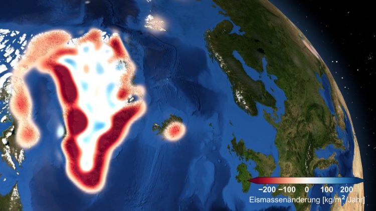
The graphic shows the ice-sheet loss in Greenland – based on GOCO06S © IFG – TU Graz
The Earth’s gravity fluctuates from place to place. Geodesists use this phenomenon to observe geodynamic and climatological processes. Using satellite-supported recordings, they document the strong fluctuations and the associated spatial and seasonal distributions of mass on and in the Earth.
From this, gravity field models can be calculated by which researchers can track rising sea levels or melting glaciers, investigate regional groundwater reserves more closely or analyse oceanic currents.
A team at the Institute of Geodesy of TU Graz has published a new combined gravity field model. The model, which is called GOCO06S, represents changes in mass on and under the Earth’s surface at unprecedented accuracy.
Model brings together different measuring processes
The name refers to the initiative itself: Gravity Observation Combination (GOCO), in whose framework the model was developed together with international partners. The consortium combines 1.16 billion measurements recorded by 19 satellites. “Due to the combination of data, the strengths of the individual measurement methods can be taken advantage of to the best of our ability.
This makes it possible for us to detect changes in the gravity field on a scale of one millionth of the mean force of gravity [Note: 9.81m/s2],” explains Torsten Mayer-Gürr, head of the Working Group of Theoretical Geodesy and Satellite Geodesy at TU Graz’s Institute of Geodesy. To achieve consistent global accuracy, it was decided to do without terrestrial data. Compared to the previous model, results have been improved by 25 percent.
The working group is occupied with determining the temporal changes in the Earth’s gravity and the evaluation of gravity measurements. The Graz team processes data from satellite missions and makes available gravity field solutions to the scientific community. “Our models are also used, for instance, in research into flood events,” says Mayer-Gürr, naming one particular field of activity.
About the Gravity Observation Combination initiative
The GOCO initiative has been around since 2009. It’s aim is to calculate high-precision and high-resolution global gravity field models through the combination of many different data sources. In 2010, the world’s first combination solution from the GRACE and GOCE missions was able to be calculated using the GOCO01s model.
This was followed by the successor models GOCO02s (2011), GOCO03s (2012) and GOCO05s (2015). The latest model generation GOCO06s combines data from GRACE, GOCE and the kinematic low-Earth-orbit satellites CHAMP, SWARM, TerraSAR-X, TanDEM-X and the laser satellites LAGEOS1/2, Ajisai, Stella, Starlette, LARES, LARETS, Etalon1/2 and BLITS.
GOCO cooperation partners:
Institute of Astronomical and Physical Geodesy, TU München
Institute of Geodesy and Geoinformation, University of Bonn
Institute of Geodesy of TU Graz – Working Group Theoretical Geodesy and Satellite Geodesy
Space Research Institution (IWF), Austrian Academy of Sciences
Astronomical Institute, University of Bern
This research area is anchored in the Field of Expertise “Sustainable Systems”, one of five strategic foci of TU Graz.
Torsten MAYER-GÜRR
Univ.-Prof. Dr.-Ing.
TU Graz | Institute of Geodesy, Working Group Theoretical Geodesy and Satellite Geodesy
Steyrergasse 30/III, 8010 Graz
Tel. +43 316 873 6359
mayer-guerr@tugraz.at
ifg.tugraz.at
https://www.tugraz.at/institutes/ifg/downloads/gravity-field-models/goco-series/ (Further information on the GOCO-Project)
https://www.bgu.tum.de/en/iapg/welcome/?tx_curlcontent_pi1%5Bc2825%5D=46
https://www.igg.uni-bonn.de/en?set_language=en
https://www.tugraz.at/institute/ifg/research/theoretical-geodesy-and-satellite-g…
Media Contact
All latest news from the category: Earth Sciences
Earth Sciences (also referred to as Geosciences), which deals with basic issues surrounding our planet, plays a vital role in the area of energy and raw materials supply.
Earth Sciences comprises subjects such as geology, geography, geological informatics, paleontology, mineralogy, petrography, crystallography, geophysics, geodesy, glaciology, cartography, photogrammetry, meteorology and seismology, early-warning systems, earthquake research and polar research.
Newest articles

First-of-its-kind study uses remote sensing to monitor plastic debris in rivers and lakes
Remote sensing creates a cost-effective solution to monitoring plastic pollution. A first-of-its-kind study from researchers at the University of Minnesota Twin Cities shows how remote sensing can help monitor and…

Laser-based artificial neuron mimics nerve cell functions at lightning speed
With a processing speed a billion times faster than nature, chip-based laser neuron could help advance AI tasks such as pattern recognition and sequence prediction. Researchers have developed a laser-based…

Optimising the processing of plastic waste
Just one look in the yellow bin reveals a colourful jumble of different types of plastic. However, the purer and more uniform plastic waste is, the easier it is to…


