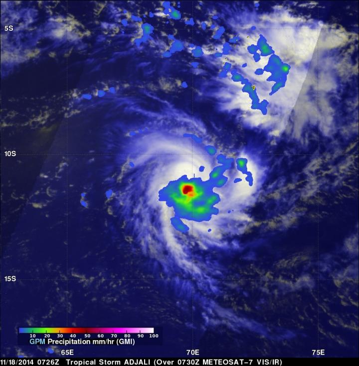
GPM measured Tropical Storm Adjali's rainfall before dissipation

The GPM satellite found that rainfall was falling at a rate of over 69 mm/2.7 inches per hour near the center on Tropical Storm Adjali on Nov. 18. Credit: Image Credit: SSAI/NASA, Hal Pierce
Adjali became the first named storm of the Southwest Indian Ocean 2014/2015 cyclone season when it formed on November 16, 2014. Adjali became a strong tropical storm the next day and just two days later started to dissipate.
The GPM observatory captured data on Adjali's rainfall rates on Nov. 18. GPM's Microwave Imager (GMI) instrument is similar to the Tropical Rainfall Measuring Mission's (TRMM's) Microwave Imager (TMI) which also provide rainfall rates of storms, but TRMM is limited to the tropics while GPM provides near real time global coverage of precipitation.
When GPM flew over Adjali on November 18, 2014 at 0726 UTC (2:26 a.m. EST), GPM's Microwave Imager (GMI) instrument collected data on the rate in which rainfall was occurring. GMI data showed that rain was falling at a rate of over 69 mm/about 2.7 inches per hour near the center of the tropical storm.
To create a total picture of the storm, the GPM rainfall data was combined with a visible/infrared image of Adjali's clouds as seen from Europe's METEOSAT-7 on November 18, 2014 at 0730 UTC. That image was created at NASA's Goddard Space Flight Center in Greenbelt, Maryland.
Late on Nov. 19 the atmospheric conditions around Tropical Cyclone Adjali became hostile as wind shear increased and tore the storm apart. At 2100 UTC (4 p.m. EST) the Joint Typhoon Warning Center (JTWC) issued their final bulletin on the storm. At that time, Tropical Cyclone Adjali was centered near 13.3 south latitude and 70.0 east longitude, about 400 nautical miles south-southwest of the island of Diego Garcia. It was moving to the west-northwest at 4 knots (4.6 mph/7.4 kph) and had maximum sustained winds near 35 knots (40 mph/64 kph). The JTWC noted at that time that “Adjali is currently dissipating under hostile conditions.”
By November 20, Adjali had dissipated in the Southern Indian Ocean putting an end to the first tropical cyclone of the Southern Indian Ocean season.
Global Precipitation Measurement (GPM) is an international satellite mission that will set a new standard for precipitation measurements from space, providing the next-generation observations of rain and snow worldwide every three hours. The GPM mission data will advance our understanding of the water and energy cycles and extend the use of precipitation data to directly benefit society. For more information about GPM, visit: http://www.nasa.gov/gpm
Harold F. Pierce / Rob Gutro
SSAI/NASA Goddard Space Flight Center
Media Contact
All latest news from the category: Earth Sciences
Earth Sciences (also referred to as Geosciences), which deals with basic issues surrounding our planet, plays a vital role in the area of energy and raw materials supply.
Earth Sciences comprises subjects such as geology, geography, geological informatics, paleontology, mineralogy, petrography, crystallography, geophysics, geodesy, glaciology, cartography, photogrammetry, meteorology and seismology, early-warning systems, earthquake research and polar research.
Newest articles

First-of-its-kind study uses remote sensing to monitor plastic debris in rivers and lakes
Remote sensing creates a cost-effective solution to monitoring plastic pollution. A first-of-its-kind study from researchers at the University of Minnesota Twin Cities shows how remote sensing can help monitor and…

Laser-based artificial neuron mimics nerve cell functions at lightning speed
With a processing speed a billion times faster than nature, chip-based laser neuron could help advance AI tasks such as pattern recognition and sequence prediction. Researchers have developed a laser-based…

Optimising the processing of plastic waste
Just one look in the yellow bin reveals a colourful jumble of different types of plastic. However, the purer and more uniform plastic waste is, the easier it is to…


