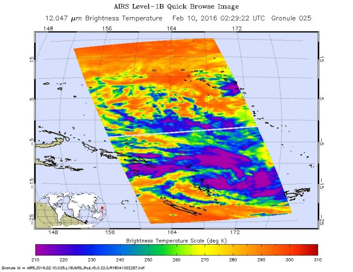

On Feb. 10 at 0229 UTC, AIRS saw strongest storms with cloud top temperatures colder than minus 63 degrees Fahrenheit (minus 53 degrees Celsius) north, east and south of the center.
Credits: NASA Goddard MODIS Rapid Response Team
The Atmospheric Infrared Sounder or AIRS instrument that flies aboard NASA's Aqua satellite measured temperatures in Tropical Storm 11P's cloud tops on Feb. 10 at 0229 UTC (Feb. 9 at 9:22 p.m. EST). AIRS provides valuable temperature data for tropical cyclones such as cloud top and sea surface temperatures.
AIRS saw strongest storms with cloud top temperatures colder than minus 63 degrees Fahrenheit (minus 53 degrees Celsius) north, east and south of the center.
NASA research has shown that storms with cloud tops that cold are powerful enough to generate heavy rain. Animated infrared satellite imagery showed the low-level circulation center was rapidly consolidating, and the banding of thunderstorms around the center had improved.
The Visible Infrared Imaging Radiometer Suite (VIIRS) instrument aboard NASA-NOAA's Suomi NPP satellite provided a visible look at Tropical Storm 11S on Feb. 10 at 02:25 UTC (9:25 p.m. EST, Feb. 9) that showed it was between the island nations of Vanuatu to the west, and Fiji to the east.
At 1500 UTC (10 a.m. EST), the Joint Typhoon Warning Center (JTWC) noted that Tropical Storm 11P (TS 11P) had maximum sustained winds near 35 knots (40 mph/62 kph).
It was centered near 15.7 degrees south latitude and 171.1 east longitude, about 463 nautical miles west-northwest of Suva, Fiji. TS 11P has tracked south-southeastward at 9 knots
Tropical Storm 11P is forecast to reach hurricane-strength in a day and peak on Feb. 12 with sustained winds near 105 knots (121 mph) before starting to weaken.


