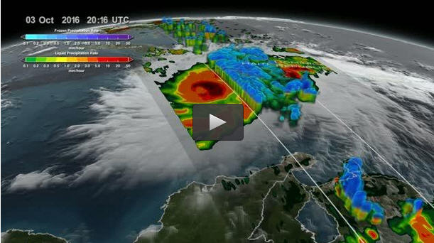

This animation of GPM data shows Hurricane Matthew from Oct. 4 through 6, 2016. On Oct. 4 Matthew's eye made landfall over Haiti. GPM's saw tremendous amounts of rainfall throughout Haiti. On Oct. 6 Matthew approached Florida where outer bands of precipitation were near the Florida coast. GPM revealed the massive amounts of rainfall being produced by this storm as it begins to impact Florida.
Credits: NASA SVS
An eyewall consists of powerful thunderstorms in the area immediately outside the eye of a hurricane. Those storms have very heavy rainfall and strong winds.
“GPM had a recent overpass at 3:06 p.m. EDT that shows that Matthew is undergoing an eyewall replacement cycle,” said Scott Braun, research meteorologist at NASA's Goddard Space Flight Center in Greenbelt, Maryland. “The GPM image showed concentric rings of precipitation. The inner ring is the original eyewall, the larger outer ring is the new one.”
“When this occurs, there is a transition from a small, extremely intense inner core of winds to a larger wind field that is not as intense at its maximum, but more spread out. In Matthew's case, the winds have weakened from 140 to 120 mph moving it from category 4 to 3,” Braun said.
The larger eye means that the center of the storm does not have to track as close to the coast for the coast to experience the strong winds in the eyewall.
NASA's Kennedy Space Center has already felt the effects of Matthew. “Hurricane Matthew is passing Cape Canaveral and Kennedy Space Center at this time with sustained winds of 90 mph with gusts to 107 mph,” said George Diller of the Office of Communications at NASA's Kennedy Space Center, Cape Canaveral, Florida. “The storm is passing the space center about 26 miles off the tip of Cape Canaveral.”
At 8 a.m. EDT on Oct. 7, the National Hurricane Center (NHC) noted “Eyewall of dangerous Hurricane Matthew hugging the coast of central Florida.”
A Hurricane Warning is in effect for Sebastian Inlet to South Santee River, Florida. A Tropical Storm Warning is in effect for Jupiter Inlet to Sebastian Inlet; Anclote River to Suwannee River; North of South Santee River to Surf City. A Tropical Storm Watch is in effect for Anna Maria Island to Anclote River.
At 8 a.m. EDT (1200 UTC), the eye of Hurricane Matthew was located near 28.9 degrees north latitude and 80.3 degrees west longitude.
Maximum sustained winds are near 120 mph (195 kph) with higher gusts. Matthew is a category 3 hurricane on the Saffir-Simpson Hurricane Wind Scale. Although weakening is forecast during the next 48 hours, Matthew is expected to be a category 3 hurricane as it moves near the coast of Florida today.
Hurricane-force winds extend outward up to 60 miles (95 km) from the center, and tropical-storm-force winds extend outward up to 185 miles (295 km). Cape Canaveral recently reported and wind gust to 97 mph (155 kph), and Daytona Beach reported a wind gust of 67 mph (110 kph).
Matthew is moving toward the north-northwest near 13 mph (20 kph), and this general motion is expected to continue today. NHC said turn toward the north is expected tonight or Saturday. On the forecast track, the center of Matthew will be moving near or over the east coast of the Florida peninsula through tonight, and near or over the coasts of Georgia and South Carolina on Saturday, Oct. 8.
The latest minimum central pressure reported by the reconnaissance aircraft was 944 millibars.
For NHC forecast updates, conditions and tracks visit: http://www.


