


Feeding 9 Billion: Innovations in Agricultural Modeling
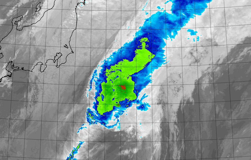
NASA's Terra satellite passed over Tropical Storm Nuri on Nov. at captured an infrared picture of the storm. Nuri looked more like a frontal system stretching from northeast to southwest.
Image Credit: NASA/NRL
The Moderate Resolution Imaging Spectroradiometer or MODIS instrument that flies aboard NASA's Terra satellite flew over Nuri on Nov. 6 at 1240 UTC (7:40 a.m. EST).
The MODIS image showed some strong thunderstorms remaining in a small area around Nuri's center, but the storm appeared stretched out from northeast to southwest. Wind shear was affecting the storm, stretching it out.
The last bulletin on the storm was issued on Nov. 6 at 0300 UTC (Nov. 5 at 10 p.m. EST). At that time, the Joint Typhoon Warning Center (JTWC) noted that Nuri still had maximum sustained winds near 55 knots (63.2 mph/102 kph).
It was located about 130 nautical miles (149 miles/240 km) west-northwest of Chichi-jima, near 29.2 north latitude and 141.0 east longitude. Nuri was moving to the northeast and over open waters of the western North Pacific.
In its final bulletin, JWTC noted that Nuri will become an extra-tropical storm before the end of the day on Nov. 6. Computer models indicate the system will be a strong extra-tropical low pressure area as it continues to move over open waters.
Rob Gutro
NASA's Goddard Space Flight Center


In the global carbon cycle microorganisms have evolved a variety of methods for fixing carbon. Researchers from Bremen and Taiwan have investigated the methods that are utilized at extremely hot, acidic and sulfur-rich hydrothermal vents in shallow waters off the island of Kueishantao, Taiwan. A team working with first author Joely Maak of MARUM – Center for Marine Environmental Sciences at the University of Bremen has now published their study in the professional journal Biogeosciences. Extremely harsh conditions can be…

The sun may rise every morning, but the amount of sunlight reaching the Earth’s surface can substantially vary over decades, according to a perspectives article led by an international research team. The article, published on March 15 in Advances in Atmospheric Science, suggests that stages of “dimming” and “brightening” correspond with increased air pollution and implementation of clean energy solutions, respectively. “The amount of sunlight — which is solar radiative energy — we receive at the Earth’s surface is not…

New research explores geological processes along plate boundaries Being a geophysicist can sometimes feel like being a detective —uncovering clues, and then building a case based on the evidence. In a new article published in Science Advances, a collaborative team led by the Woods Hole Oceanographic Institution (WHOI), presents a never-before-seen image of an oceanic transform fault from electromagnetic (EM) data collected at the Gofar fault in the eastern Pacific Ocean. The National Science Foundation funded work reveals unexpected brine…

Study shows contrast between wet and dry areas increases rain by up to 30% Storm forecasting is traditionally based on studying atmospheric conditions but ground-breaking research that also looks at land surface conditions is set to transform early warning systems in tropical regions. This will enable communities to better adapt to the destructive impacts of climate change. The new study led by the UK Centre for Ecology & Hydrology (UKCEH) has shown that a large contrast in soil moisture levels…


