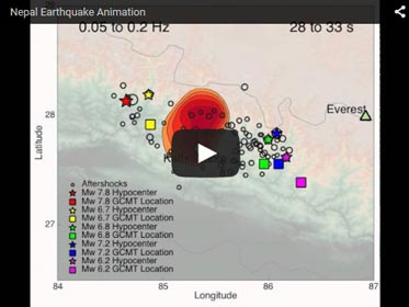

Nepal Earthquake Animation
New research has accurately mapped out the movement of the devastating 7.8-magnitude Nepal earthquake that killed over 9,000 and injured over 23,000 people. Scientists have determined that the earthquake was a rupture consisting of three different stages. The study could help a rapidly growing region understand its future seismic risks, according to the study’s authors.
The Himalayan region is particularly prone to earthquakes and this study will serve as an important benchmark for understanding where future earthquakes may occur, especially since the area has experienced high population growth over the past few decades, the study’s authors said.
The study assessed the presence of low frequency and high frequency waves over the three stages of the earthquake. High frequency waves cause more shaking, thereby posing the greatest risks for structural damages. Low frequency waves are less violent and less damaging to buildings and infrastructure.
“The Nepal earthquake is a warning sign that the region is of high seismic risk, and each earthquake behaves differently. Some earthquakes jump from one fault line to another, whereas the Nepal quake apparently occurred on the same fault line in three different stages, moving eastward,” said Peter Shearer, a geophysicist at Scripps Institution of Oceanography at UC San Diego in La Jolla, California, and a co-author of the new study. “Using this research, we can better understand and identify areas of high seismic hazard in the region.”
This first peer-reviewed study on the April 2015 earthquake in Nepal, “Detailed rupture imaging of the 25 April 2015 Nepal earthquake using teleseismic P waves” was published online July 16 in the American Geophysical Union (AGU) journal Geophysical Research Letters.
Using the Global Seismic Network (GSN), Shearer and Scripps graduate student Wenyuan Fan were able to unravel the complex evolution of fault slips during this earthquake. The study concludes that the rupture traveled mostly eastward and occurred in three distinct stages; Stage 1 was weak and slow; Stage 2 was near Kathmandu and had the greatest slip but was relatively deficient in high-frequency radiation; and Stage 3 was relatively slow as well. Overall, this earthquake was more complicated, with multi-stage movements on multiple faults, than smooth models of continuous rupture on a single fault plane.
“Using the GSN instead of regional array data really enhanced the spatial resolution of the back-projection images and helped us see that frequency-dependent rupture was one of the main features of this earthquake,” said Fan. “Stage 2 was high-frequency-deficient and occurred closest to Kathmandu, which was probably why ground shaking was less severe than expected for such a high-magnitude earthquake.”
The Global Seismic Network provides high-quality broadband digital seismic data for monitoring earthquakes and learning about Earth’s structure. Fan and Shearer used the GSN data because they are open-source, have good coverage of the Nepal region, and have a long history of reliable recordings.
“In general, understanding large earthquakes will inform our ability to forecast the nature of future earthquakes,” said Shearer.
Shearer and Fan hope to use the same methodology to study other large, global earthquakes from the past decade to provide a broader picture of earthquake behavior and help in predicting ground shaking for future events.
The study was funded by the National Science Foundation.
The American Geophysical Union is dedicated to advancing the Earth and space sciences for the benefit of humanity through its scholarly publications, conferences, and outreach programs. AGU is a not-for-profit, professional, scientific organization representing more than 60,000 members in 139 countries. Join the conversation on Facebook, Twitter, YouTube, and our other social media channels.
Notes for Journalists
Journalists and public information officers (PIOs) of educational and scientific institutions who have registered with AGU can download a PDF copy of the article by clicking on this link: http://onlinelibrary.wiley.com/doi/10.1002/2015GL064587/full?campaign=wlytk-41855.5282060185
Or, you may order a copy of the final paper by emailing your request to Nanci Bompey at nbompey@agu.org. Please provide your name, the name of your publication, and your phone number.
Neither the papers nor this press release is under embargo.
Title
“Detailed rupture imaging of the 25 April 2015 Nepal earthquake using teleseismic P waves”
Authors:
W. Fan and P. M. Shearer: Scripps Institution of Oceanography, University of California, San Diego, La Jolla, California, USA.
Contact Information for the Authors:
Wenyuan Fan: w3fan@ucsd.edu
Peter Shearer: +1 (858) 534-2260, pshearer@ucsd.edu
AGU Contact:
Nanci Bompey
+1 (202) 777-7524
nbompey@agu.org
Scripps Contact:
Christina Wu
+1 (858) 534-3654
chw261@ucsd.edu


