


Feeding 9 Billion: Innovations in Agricultural Modeling
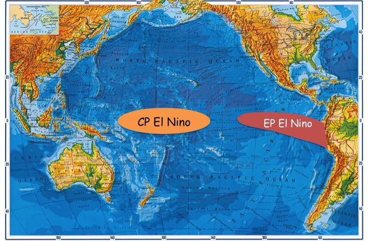
In addition to the eastern Pacific El Niño which we have been quite familiar with, a second El Niño in the central Pacific has emerged.
Credit: Fei Zheng
Recently, a new type of El Niño [central Pacific (CP) El Niño] has emerged, in which maximum sea surface temperature (SST) anomalies are confined mostly to the CP–different to the canonical type [eastern Pacific (EP) El Niño], in which the maximum SST anomalies are located in the eastern Pacific.
The more frequent occurrence of CP El Niño and its different impacts on global climate compared to EP El Niño have been well documented.
However, a systematic examination of the performance of climate models in predicting the two types of El Niño had yet to be undertaken, and it remained controversial as to whether the predictability differs among state-of-the-art climate models.
Prof. Fei Zheng, from the Institute of Atmospheric Physics, Chinese Academy of Sciences and Prof. Jin-Yi Yu, from the University of California, Irvine, explored the performance of the IAP's ENSO ensemble prediction system with respect to the two types of El Niño, focusing on the nine EP El Niño and twelve CP El Niño events that have occurred since 1950.
“We found that the skill scores for EP events were significantly better than those for CP events at all lead times,” says Zheng, “the possible reasons are related to the systematic forecast biases coming mostly from the prediction of CP events; and systematic error characterized by an overly warm eastern Pacific during the spring season, indicating a stronger spring prediction barrier for CP El Niño.”
Further improvements to coupled atmosphere-ocean models in terms of CP El Niño prediction should be recognized as a key and high-priority task for the climate prediction community. The study was recently published in Advanced in Atmospheric Sciences.


Plate temperature and water release can explain the occurrence of different types of earthquakes in Guerrera, Mexico. The Kobe University simulation study also showed that the shape of the Cocos Plate is responsible for a gap where earthquakes haven’t occurred for more than a century. The results are important for accurate earthquake prediction models in the region. Where one tectonic plate is pushed down by another, the resulting stress is released in various tectonic events. There are catastrophic megathrust earthquakes,…

Deep below Earth’s surface, rock and mineral formations lay hidden with a secret brilliance. Under a black light, the chemicals fossilized within shine in brilliant hues of pink, blue and green. Scientists are using these fluorescent features to understand how the caves formed and how life is supported in extreme environments, which may reveal how life could persist in faraway places, like Jupiter’s icy moon Europa. The researchers will present their results at the spring meeting of the American Chemical…

Recent studies have shown that carbon stocks in terrestrial ecosystems are increasing, mitigating around 30% of the CO2 emissions linked to human activities. The overall value of carbon sinks on the earth’s surface is fairly well known—as it can be deduced from the planet’s total carbon balance anthropogenic emissions, the accumulation of carbon in the atmosphere and the ocean sinks—yet, researchers know very little about carbon distribution between the various terrestrial pools: living vegetation—mainly forests—and nonliving carbon pools—soil organic matter,…

An analysis of a 30,000-year-old fossil vulture from Central Italy has revealed for the first time that volcanic rock can preserve microscopic details in feathers – the first ever record of such a preservation. An international team, led by Dr Valentina Rossi (University College Cork, Ireland), discovered a new mode of preservation of soft tissues that can occur when animals are buried in ash-rich volcanic sediments. The new research, published in the scientific journal Geology, reveals that the feathers are…


