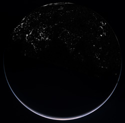
Rosetta: OSIRIS’ view of Earth by night

This is a composite of four images combined to show the illuminated crescent of Earth and the cities of the northern hemisphere. The images were acquired with the OSIRIS Wide Angle Camera (WAC) during Rosetta’s second Earth swing-by on 13 November. This image showing islands of light created by human habitation was taken with the OSIRIS WAC at 19:45 CET, about 2 hours before the closest approach of the spacecraft to Earth. At the time, Rosetta was about 80 000 km above the Indian Ocean where the local time approached midnight (the angle between Sun, Earth and Rosetta was about 160°). The image was taken with a five-second exposure of the WAC with the red filter. This image showing Earth’s illuminated crescent was taken with the WAC at 20:05 CET as Rosetta was about 75 000 km from Earth. The crescent seen is around Antarctica. The image is a colour composite combining images obtained at various wavelengths. Credits: ESA ©2005 MPS for OSIRIS Team MPS/UPD/LAM/IAA/RSSD/INTA/UPM/DASP/IDA
The images were acquired with the OSIRIS Wide Angle Camera (WAC) during Rosetta’s second Earth swing-by on 13 November.
This image showing islands of light created by human habitation was taken with the OSIRIS WAC at 19:45 CET, about 2 hours before the closest approach of the spacecraft to Earth.
At the time, Rosetta was about 80 000 km above the Indian Ocean where the local time approached midnight (the angle between Sun, Earth and Rosetta was about 160°). The image was taken with a five-second exposure of the WAC with the red filter.
This image showing Earth’s illuminated crescent was taken with the WAC at 20:05 CET as Rosetta was about 75 000 km from Earth.
The crescent seen is around Antarctica. The image is a colour composite combining images obtained at various wavelengths.
Media Contact
More Information:
http://www.esa.int/SPECIALS/Rosetta/SEM3HV53R8F_0.htmlAll latest news from the category: Earth Sciences
Earth Sciences (also referred to as Geosciences), which deals with basic issues surrounding our planet, plays a vital role in the area of energy and raw materials supply.
Earth Sciences comprises subjects such as geology, geography, geological informatics, paleontology, mineralogy, petrography, crystallography, geophysics, geodesy, glaciology, cartography, photogrammetry, meteorology and seismology, early-warning systems, earthquake research and polar research.
Newest articles

An Endless Loop: How Some Bacteria Evolve Along With the Seasons
The longest natural metagenome time series ever collected, with microbes, reveals a startling evolutionary pattern on repeat. A Microbial “Groundhog Year” in Lake Mendota Like Bill Murray in the movie…

Witness Groundbreaking Research on Achilles Tendon Recovery
Achilles tendon injuries are common but challenging to monitor during recovery due to the limitations of current imaging techniques. Researchers, led by Associate Professor Zeng Nan from the International Graduate…

Why Prevention Is Better Than Cure—A Novel Approach to Infectious Disease Outbreaks
Researchers have come up with a new way to identify more infectious variants of viruses or bacteria that start spreading in humans – including those causing flu, COVID, whooping cough…


