NASA Observes Super Typhoon Hagupit; Philippines Under Warnings

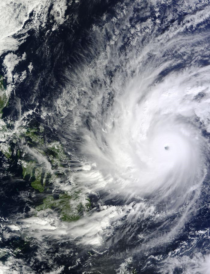
On Dec. 4 at 02:10 UTC, the MODIS instrument aboard NASA's Terra satellite took this visible image of Super Typhoon Hagupit approaching the Philippines. Image Credit: NASA Goddard's MODIS Rapid Response Team
NASA's Terra satellite and NASA/JAXA's GPM and TRMM satellites have been providing forecasters with valuable data on the storm. Computer models have varied on their track for the storm based on the strength of an upper-level system, so satellite data is extremely valuable in helping determine where Hagupit will move.
On Dec. 3, typhoon Hagupit was moving from near Palau toward the Philippines when it was examined by two satellites managed by NASA and the Japan Aerospace Exploration Agency known as JAXA. The Tropical Rainfall Measuring Mission or TRMM satellite and the Global Precipitation Measurement or GPM core satellite passed over Hagupit and gathered rainfall and cloud height data.
The TRMM satellite traveled directly over Typhoon Hagupit's eye on December 3, 2014 at 0342 UTC (Dec. 2 at 10:42 p.m. EST). The GPM (core satellite) had a good view of Hagupit later at 1041 UTC (5:41 a.m. EST) Rainfall data captured at that time with GPM's Microwave Imager (GMI) instrument shows that rain was falling at a rate of over 138 mm (~5.4 inches) per hour in the western side of Hagupit's eye.
At NASA's Goddard Space Flight Center in Greenbelt, Maryland the data from the Ku band on GPM's dual frequency radar instrument (DPR) was used to create a 3-D image. The Ku band radar swath showed powerful thunderstorms reaching heights of over 15.8 km (9.8 miles) in feeder bands west of Typhoon Hagupit's eye.
On Dec. 4 at 02:10 UTC, the MODIS (Moderate Resolution Imaging Spectroradiometer) instrument aboard NASA's Terra satellite took a visible image of Super Typhoon Hagupit approaching the Philippines. The MODIS image showed a clear eye surrounded by strong thunderstorms and bands of thunderstorms wrapping into the low-level center. The image also showed that the bulk of strongest thunderstorms were being pushed slightly west of the center as a result of easterly wind shear.
At 1500 UTC (10 a.m. EST) Typhoon Hagupit's maximum sustained winds were near 150 knots (172.6 mph/ 277.8 kph). Currently, typhoon-force winds of 64 knots (74 mph/118.5 kph) or higher occur out to 55 miles of the center. Tropical Storm-force winds of 34 knots (39 mph/63 kph) or higher occur within 85 to 140 miles of the center. The eye was centered near 11.1 north longitude and 130.9 east latitude, about 640 nautical miles (736 miles/1,185 km) east-southeast of Manila, Philippines. Hagupit was moving to the west-northwest at 12 knots 13.8 mph/22.2 kph).
Warnings in Effect
Philippines warnings in effect as of Dec. 4 include: Public storm warning signal #2 for the following provinces: Visayas: Northern and eastern Samar, Samar, Biliran, Leyte and southern Leyte
Mindanao: Dinagat Island and Siargao Island. And public storm warning signal #1 in effect for the following provinces: Visayas: Northern Cebu including Bantayan island, Camotes island and Bohol; Mindanao: Surigao del Norte & Sur, Camiguin Island and Agusan del Norte; Luzon: Catanduanes, Albay, Sorsogon, Ticao Island and Masbate.
Current Forecast Track from the JTWC
The Joint Typhoon Warning Center (JTWC) current forecast track for Super Typhoon Hagupit projects the eye of the typhoon just over the northeastern tip of Eastern Visayas on Dec. 6 before making landfall over the Bicol region on Dec. 7. The storm is forecast to continue tracking in a northwesterly direction thereafter.
Maximum sustained winds at the time of approach to Eastern Visayas are expected be at Category 4 strength on the Saffir-Simpson scale, although the interaction with land is expected to continue weakening the storm.
The JTWC forecast calls for Hagupit to remain at typhoon strength as it crosses the Philippines and moves into the South China Sea.
Question in the Forecast Track
As of Dec. 4, not all computer models agree on the exact track the storm will take because of an area of low pressure forecast to move in from the north. Some computer models project that the low pressure system will be strong and would take Hagupit on a more westerly direction over the Central Philippines. Other computer models are projecting that the low pressure area to the north of Hagupit will not be so strong, which will allow the storm to maintain movement in a northwesterly direction.
As satellites gather more information, computer models will update atmospheric conditions that will steer the storm and forecasters will reassess the track as Hagupit nears the Philippines over the next couple of days.
Rob Gutro
NASA's Goddard Space Flight Center, Greenbelt, Maryland
Media Contact
All latest news from the category: Earth Sciences
Earth Sciences (also referred to as Geosciences), which deals with basic issues surrounding our planet, plays a vital role in the area of energy and raw materials supply.
Earth Sciences comprises subjects such as geology, geography, geological informatics, paleontology, mineralogy, petrography, crystallography, geophysics, geodesy, glaciology, cartography, photogrammetry, meteorology and seismology, early-warning systems, earthquake research and polar research.
Newest articles

NASA: Mystery of life’s handedness deepens
The mystery of why life uses molecules with specific orientations has deepened with a NASA-funded discovery that RNA — a key molecule thought to have potentially held the instructions for…

What are the effects of historic lithium mining on water quality?
Study reveals low levels of common contaminants but high levels of other elements in waters associated with an abandoned lithium mine. Lithium ore and mining waste from a historic lithium…

Quantum-inspired design boosts efficiency of heat-to-electricity conversion
Rice engineers take unconventional route to improving thermophotovoltaic systems. Researchers at Rice University have found a new way to improve a key element of thermophotovoltaic (TPV) systems, which convert heat…


