Two NASA satellites see Tropical Storm Andres intensify

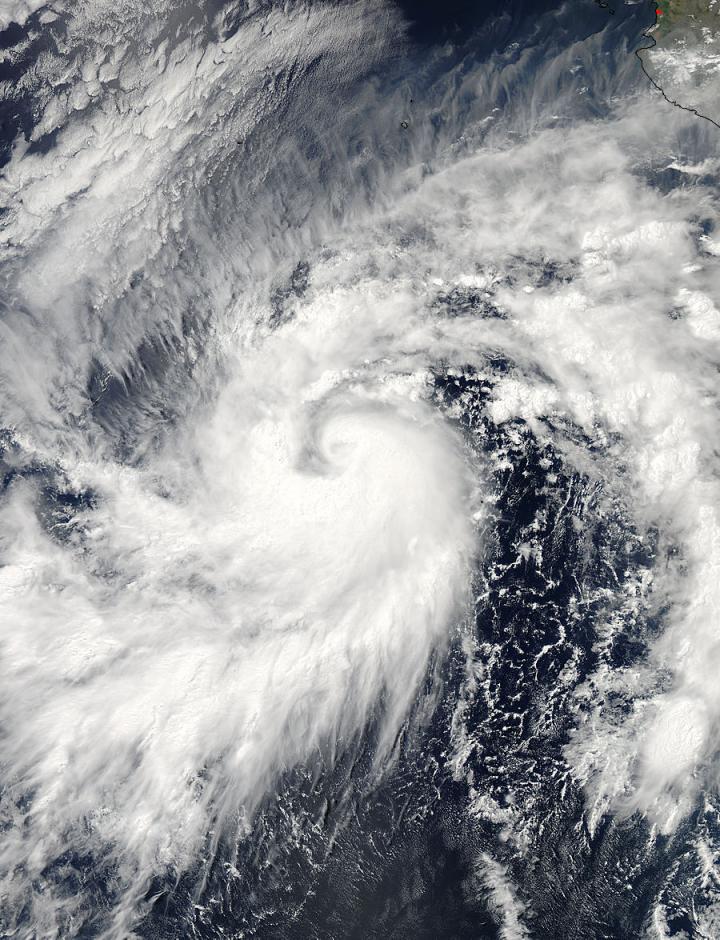
The MODIS instrument on NASA's Aqua satellite captured this image of Tropical Storm Andres on May 28 at 2100 UTC (5 p.m. EDT), about six hours after it intensified into a tropical storm. Courtesy of NASA Goddard MODIS Rapid Response
Tropical storm Andres became the first tropical storm of the 2015 Eastern Pacific hurricane season on May 28 at 1500 UTC (11 a.m. EDT). The GPM core observatory satellite flew over the intensifying tropical depression, then known as tropical depression 01E at 1225 UTC (8:25 a.m. EDT).
At NASA's Goddard Space Flight Center in Greenbelt, Md., rainfall data from GPM's Microwave Imager (GMI) and Dual-Frequency Precipitation Radar (Ku Band) instruments were overlaid on an enhanced GOES-East satellite infrared image to create a three-dimensional picture of the storm.
The data showed that rainfall was occurring at a rate of over 60 mm (2.4 inches) per hour in powerful convective storms near Andres' center. GPM radar data showed tall thunderstorms reaching heights of over 15 km (9.3 miles) in a band of thunderstorms.
Eight and a half hours later, the MODIS, or Moderate Resolution Imaging Spectroradiometer, instrument on NASA's Aqua satellite captured a visible light image of tropical storm Andres. On May 28 at 2100 UTC (5 p.m. EDT), about six hours after it intensified into a tropical storm MODIS data showed Andres took on the signature 'comma shape' of a tropical storm.
The bulk of clouds and showers were south of the center of circulation in a large, thick band of thunderstorms spiraling into the center. The image was created by the MODIS Rapid Response Team at NASA Goddard.
At the same time, the Atmospheric Infrared Sounder ,or AIRS, instrument aboard Aqua captured infrared data. Infrared data indicates temperatures, and the higher the thunderstorms are in the troposphere, the colder the temperature. The colder, higher thunderstorms are more powerful storms with the capability of dropping heavier rainfall.
AIRS measured some cloud top temperatures near the center of circulation at minus 63 degrees Fahrenheit (minues 53 degrees Celsius), and research has shown that those storms can generate heavy rainfall.
At 9 a.m. EDT (1500 UTC), the center of tropical storm Andres was located near latitude 12.5 north and longitude 114.6 west, about 780 miles (1,260 km) south-southwest of the southern tip of Baja, Calif.. Andres is moving toward the west-northwest near 9 mph (15 kph). A northwestward motion at a slightly slower forward speed is expected continue through Saturday night.
Maximum sustained winds remain near 70 mph (110 kph) with higher gusts. Some strengthening is forecast during the next 48 hours, and Andres is expected to become a hurricane later in the day on May 29. Tropical storm force winds extend outward up to 115 miles (185 km) from the center. The estimated minimum central pressure is 994 millibars (29.36 inches).
During the past month the National Oceanic and Atmospheric Administration (NOAA) has observed warmer sea surface temperatures in the eastern Pacific Ocean. This indicates that El Nino is becoming stronger. El Nino usually means stronger hurricane activity in the central and eastern pacific basins so many other tropical cyclones are likely to follow Andres lead in the eastern Pacific.
The National Hurricane Center expects Andres' winds to peak on May 31 near 100 mph before a weakening trend commences. Andres is expected to remain at sea, and move in a northwesterly direction over the next several days.
Media Contact
All latest news from the category: Earth Sciences
Earth Sciences (also referred to as Geosciences), which deals with basic issues surrounding our planet, plays a vital role in the area of energy and raw materials supply.
Earth Sciences comprises subjects such as geology, geography, geological informatics, paleontology, mineralogy, petrography, crystallography, geophysics, geodesy, glaciology, cartography, photogrammetry, meteorology and seismology, early-warning systems, earthquake research and polar research.
Newest articles

A ‘language’ for ML models to predict nanopore properties
A large number of 2D materials like graphene can have nanopores – small holes formed by missing atoms through which foreign substances can pass. The properties of these nanopores dictate many…

Clinically validated, wearable ultrasound patch
… for continuous blood pressure monitoring. A team of researchers at the University of California San Diego has developed a new and improved wearable ultrasound patch for continuous and noninvasive…

A new puzzle piece for string theory research
Dr. Ksenia Fedosova from the Cluster of Excellence Mathematics Münster, along with an international research team, has proven a conjecture in string theory that physicists had proposed regarding certain equations….


