NASA spies Extra-Tropical Storm Kate racing through North Atlantic

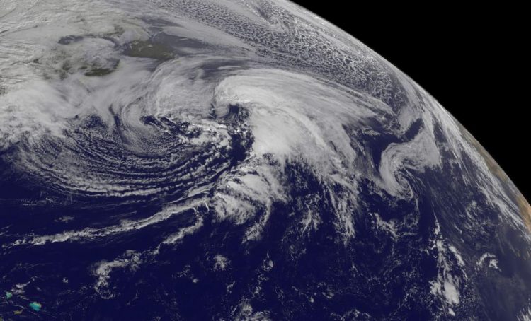
This NOAA GOES-West satellite visible image extra-tropical storm Kate shows the storm over 400 miles southeast of Newfoundland, Canada. Credits: NASA/NOAA GOES Project
A NOAA GOES-West satellite visible image extra-tropical storm Kate on Nov. 12 at 1445 UTC (9:45 a.m. EST) showed the storm over 400 miles southeast of Newfoundland, Canada. Most of the clouds associated with the post-tropical storm were north and east of the center. Forecaster Beven of the National Hurricane Center said, “Satellite imagery indicates that Kate has merged with a baroclinic zone over the north Atlantic and is now an extratropical cyclone.”
Kate Reached Hurricane Strength
On Nov. 10, the RapidScat instrument that flies aboard the International Space Station saw Hurricane Kate north of the Bahamas and its strongest winds were north of the center. Maximum sustained winds in both areas were as strong as 30 meters per second (67 mph/108 kph). On Nov. 11, those winds increased to hurricane force. Hurricane force winds extended outward up to 35 miles (55 km) from the center and tropical storm force winds extend outward up to 205 miles (335 km).
At 10 a.m. EST (1500 UTC) on Nov. 11 the center of Hurricane Kate was located near latitude 36.8 North, longitude 60.5 West. That put Kate's center about 395 miles (635 km) northeast of Bermuda and about 780 miles (1,260 km) south-southwest of Cape Race Newfoundland.
An Infrared Look at Kate
On Nov. 12 at 05:17 UTC (12:17 a.m. EST) infrared imagery from the Atmospheric Infrared Sounder or AIRS instrument aboard NASA's Aqua satellite showed fragmented strong storms east and north of Kate's center where cold cloud top temperatures were near -63F/-53C. Storms with cloud tops that cold (and high in the troposphere) have been shown to generate heavy rain.
Aqua satellite showed fragmented strong storms east and north of Kate's center.
Kate Weakens and Becomes Extra-Tropical
At 4 a.m. EST on Nov. 12, Kate was classified as an extra-tropical storm. That means that a tropical cyclone has lost its “tropical” characteristics. The National Hurricane Center defines “extra-tropical” as a transition that implies both poleward displacement (meaning it moves toward the north or south pole) of the cyclone and the conversion of the cyclone's primary energy source from the release of latent heat of condensation to baroclinic (the temperature contrast between warm and cold air masses) processes. It is important to note that cyclones can become extratropical and still retain winds of hurricane or tropical storm force.
At 4 a.m. EST on Nov. 12, Kate's maximum sustained winds were near 60 knots (70 mph). Kate was centered near 40.7 degrees north latitude and 50.8 degrees west longitude, about 430 miles south-southeast of Cape Race, Newfoundland, Canada. Kate was moving to the east-northeast at 23 knots (26 mph). Minimum central pressure was 983 millibars. The post-tropical cyclone is expected to accelerate toward the east-northeast and northeast.
Kate's Fate
The National Hurricane Center expects extra-tropical storm Kate to continue weakening, but slowly over the next couple of days. The NHC forecast keeps maximum sustained winds near 45 knots (50 mph) through Nov. 15 and by Nov. 16, Kate is expected to become absorbed by an extra-tropical low pressure area.
Additional information on this system can be found in High Seas Forecasts issued by the National Weather Service at http://www.
Media Contact
All latest news from the category: Earth Sciences
Earth Sciences (also referred to as Geosciences), which deals with basic issues surrounding our planet, plays a vital role in the area of energy and raw materials supply.
Earth Sciences comprises subjects such as geology, geography, geological informatics, paleontology, mineralogy, petrography, crystallography, geophysics, geodesy, glaciology, cartography, photogrammetry, meteorology and seismology, early-warning systems, earthquake research and polar research.
Newest articles

A ‘language’ for ML models to predict nanopore properties
A large number of 2D materials like graphene can have nanopores – small holes formed by missing atoms through which foreign substances can pass. The properties of these nanopores dictate many…

Clinically validated, wearable ultrasound patch
… for continuous blood pressure monitoring. A team of researchers at the University of California San Diego has developed a new and improved wearable ultrasound patch for continuous and noninvasive…

A new puzzle piece for string theory research
Dr. Ksenia Fedosova from the Cluster of Excellence Mathematics Münster, along with an international research team, has proven a conjecture in string theory that physicists had proposed regarding certain equations….


