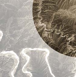
Great Wall of China seen from space

An image acquired by Proba’s High Resolution Camera on 25 March 2004 shows a short stretch of the 7240-km-long Great Wall of China snaking along hilltops northeast of Beijing, running from the top middle of the image down to bottom right. The white watercourse that meanders from the middle of the left side down to the bottom of the image is the initial part of the 1500-km-long Da Yunhe or Grand Canal, a linked series of natural and man-made waterways that represents an engineering achievement on a par with the Great Wall. <br> <br>Credits: ESA
ESA’s Proba satellite here shows a winding segment of the 7240-km long Great Wall of China situated just northeast of Beijing. The Great Wall’s relative visibility or otherwise from orbit has inspired much recent debate.
The 21 hours spent in space last October by Yang Liwei – China’s first ever space traveller – were a proud achievement for his nation. The only disappointment came as Liwei informed his countrymen he had not spotted their single greatest national symbol from orbit.
“The Earth looked very beautiful from space, but I did not see our Great Wall,” Liwei told reporters after his return.
China has cherished for decades the idea that the Wall was just about the only manmade object visible to astronauts from space, and the news disappointed many. A suggestion was made that the Wall be lit up at night so it can definitely be seen in future, while others called for school textbooks to be revised to take account of Liwei’s finding.
However such revisions may be unnecessary, according to American astronaut Eugene Cernan, speaking during a visit to Singapore: “In Earth’s orbit at a height of 160 to 320 kilometres, the Great Wall of China is indeed visible to the naked eye.”
Liwei may well have been unlucky with the weather and local atmospheric or light conditions – with sufficiently low-angled sunlight the Wall’s shadow if not the Wall itself could indeed be visible from orbit.
What is for sure is that what the human eye may not be able to see, satellites certainly can. Proba’s High Resolution Camera (HRC) acquired this image of the Wall from 600 km away in space. The HRC is a black and white camera that incorporates a miniature Cassegrain telescope, giving it far superior spatial resolution to the human eye.
So while the HRC resolves mad-made objects down to five square metres, astronauts in low Earth orbit looking with the naked eye can only just make out such large-scale artificial features as field boundaries between different types of crops or the grid shape formed by city streets. They require binoculars or a zoom lens to make out individual roads or large buildings.
About Proba
Proba (Project for On Board Autonomy) is an ESA micro-satellite built by an industrial consortium led by the Belgian company Verhaert, launched in October 2001 and operated from ESA’s Redu Ground Station (Belgium).
Orbiting 600 km above the Earth’s surface, Proba was designed to be a one-year technology demonstration mission of the Agency but has since had its lifetime extended as an Earth Observation mission. It now routinely provides scientists with detailed environmental images thanks to CHRIS – a Compact High Resolution Imaging Spectrometer developed by UK-based Sira Electro-Optics Ltd – one of the main payloads on the 100 kg spacecraft.
Also aboard is the HRC, a small-scale monochromatic camera made up of a miniature Cassegrain telescope and a 1024 x 1024 pixel Charge-Coupled Device (CCD), as used in ordinary digital cameras, taking 25-km square images to a resolution of five metres. Proba boasts an ’intelligent’ payload and has the ability to observe the same spot on Earth from a number of different angles and different combinations of optical and infra-red spectral bands. A follow-on mission, Proba-2, is due to be deployed by ESA around 2005.
Media Contact
All latest news from the category: Earth Sciences
Earth Sciences (also referred to as Geosciences), which deals with basic issues surrounding our planet, plays a vital role in the area of energy and raw materials supply.
Earth Sciences comprises subjects such as geology, geography, geological informatics, paleontology, mineralogy, petrography, crystallography, geophysics, geodesy, glaciology, cartography, photogrammetry, meteorology and seismology, early-warning systems, earthquake research and polar research.
Newest articles

Parallel Paths: Understanding Malaria Resistance in Chimpanzees and Humans
The closest relatives of humans adapt genetically to habitats and infections Survival of the Fittest: Genetic Adaptations Uncovered in Chimpanzees Görlitz, 10.01.2025. Chimpanzees have genetic adaptations that help them survive…

You are What You Eat—Stanford Study Links Fiber to Anti-Cancer Gene Modulation
The Fiber Gap: A Growing Concern in American Diets Fiber is well known to be an important part of a healthy diet, yet less than 10% of Americans eat the minimum recommended…

Trust Your Gut—RNA-Protein Discovery for Better Immunity
HIRI researchers uncover control mechanisms of polysaccharide utilization in Bacteroides thetaiotaomicron. Researchers at the Helmholtz Institute for RNA-based Infection Research (HIRI) and the Julius-Maximilians-Universität (JMU) in Würzburg have identified a…


