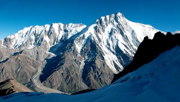
Long-term Himalayan Glacier Study

Nanga Parbat: Photo of the Rupal flank taken in 2010
Image: Marcus Nüsser
Heidelberg University geographers combine historical images and maps with current data.
The glaciers of Nanga Parbat – one of the highest mountains in the world – have been shrinking slightly but continually since the 1930s. This loss in surface area is evidenced by a long-term study conducted by researchers from the South Asia Institute of Heidelberg University. The geographers combined historical photographs, surveys, and topographical maps with current data, which allowed them to show glacial changes for this massif in the north-western Himalaya as far back as the mid-1800s.
Detailed long-term glacier studies that extend the observation period to the time before the ubiquitous availability of satellite data are barely possible in the Himalayan region due to the dearth of historical data. As Prof. Dr Marcus Nüsser from the South Asia Institute explains, this is not the case for the Nanga Parbat Massif. The earliest documents include sketch maps and drawings made during a research expedition in 1856. Based on this historical data, the Heidelberg researchers reconstructed the glacier changes along the South Face of Nanga Parbat. Additionally, there are numerous photographs and topographical maps stemming from climbing and scientific expeditions since 1934. Some of these historical photographs were retaken in the 1990s and 2010s from identical vantage points for the purpose of comparison. Satellite images dating back to the 1960s completed the data base Prof. Nüsser and his team used to create a multi-media temporal analysis and quantify glacier changes.
The Nanga Parbat glaciers largely fed by ice and snow avalanches show significantly lower retreat rates than other Himalayan regions. One exception is the mainly snow-fed Rupal Glacier, whose retreat rate is significantly higher. “Overall, more studies are needed to better understand the special influence of avalanche activity on glacier dynamics in this extreme high mountain region,” states Prof. Nüsser.
The researchers are particularly interested in glacier fluctuations, changes in ice volume, and the increase of debris-covered areas on the glacier surfaces. Their analyses covered 63 glaciers already documented in 1934. “The analyses showed that the ice-covered area decreased by approximately seven percent, and three glaciers disappeared completely. At the same time we identified a significant increase in debris coverage,” adds Prof. Nüsser. The geographical location of the Nanga Parbat Massif in the extreme northwest of the Himalayan arc near the Karakorum range could play a particular role in the comparatively moderate glacier retreat. In the phenomenon known as the Karakorum anomaly, no major glacier retreat has been identified as a result of climate change in this mountain range – as opposed to everywhere else in the world. “An increase in precipitation at high altitudes may be the reason, but the exact causes are still unknown,” explains Prof. Nüsser. The researchers assume that the low ice losses in the Karakorum and the Nanga Parbat region may also be due to the protection offered by the massive debris-cover and a year-round avalanche flow from the steep flanks.
The study shows the major potential of integrating historical material with terrestrial photography and remote sensing imagery to reconstruct glacier development over extended time periods, which is required for making the effects of global climate change visible.
The German Research Foundation funded the field work for this project. The results were published in the journal “Science of the Total Environment”. The photographic data material is available from the open-access journal “Data in Brief”.
Contact:
Communications and Marketing
Press Office
Phone +49 6221 54-2311
presse@rektorat.uni-heidelberg.de
Wissenschaftliche Ansprechpartner:
Prof. Dr Marcus Nüsser
South Asia Institute
Phone +49 6221 54-15241
marcus.nuesser@uni-heidelberg.de
Originalpublikation:
M. Nüsser, S. Schmidt: Glacier Changes on the Nanga Parbat 1856-2020: A multi-source retrospective analysis. Science of the Total Environment (2021), https://doi.org/10.1016/j.scitotenv.2021.147321
M. Nüsser, S. Schmidt: Assessing glacier changes in the Nanga Parbat region using a multitemporal photographic dataset. Data in Brief (2021), https://doi.org/10.1016/j.dib.2021.107178
Weitere Informationen:
http://www.sai.uni-heidelberg.de/geo/personen/marcus.php?lang=eng
Media Contact
All latest news from the category: Earth Sciences
Earth Sciences (also referred to as Geosciences), which deals with basic issues surrounding our planet, plays a vital role in the area of energy and raw materials supply.
Earth Sciences comprises subjects such as geology, geography, geological informatics, paleontology, mineralogy, petrography, crystallography, geophysics, geodesy, glaciology, cartography, photogrammetry, meteorology and seismology, early-warning systems, earthquake research and polar research.
Newest articles

Innovative 3D printed scaffolds offer new hope for bone healing
Researchers at the Institute for Bioengineering of Catalonia have developed novel 3D printed PLA-CaP scaffolds that promote blood vessel formation, ensuring better healing and regeneration of bone tissue. Bone is…

The surprising role of gut infection in Alzheimer’s disease
ASU- and Banner Alzheimer’s Institute-led study implicates link between a common virus and the disease, which travels from the gut to the brain and may be a target for antiviral…

Molecular gardening: New enzymes discovered for protein modification pruning
How deubiquitinases USP53 and USP54 cleave long polyubiquitin chains and how the former is linked to liver disease in children. Deubiquitinases (DUBs) are enzymes used by cells to trim protein…


