Measurement of ice flow from GPS positions logged by short-period seismographs

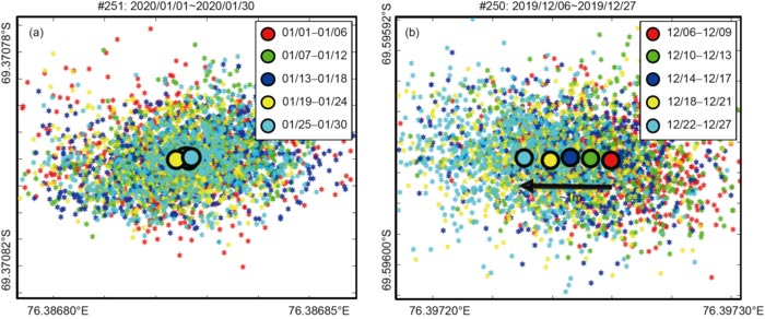
The ice flow direction and displacement during the observation period for (a) seismic station 251 located on the bedrock of Panda harbor of Zhongshan Station (its maximum displacement is approximately 0.2 m) and (b) seismic station 250 located on the Larsemann Hills ice cap (its maximum displacement is approximately 1 m). The average positions of seismic stations in different time periods are represented by red, green, blue, yellow, and cyan circles.
Credit: ©Science China Press
Seismic instruments generally have a built-in navigation-grade single-mode GPS receiver. During the operation of the station, while recording seismic data, the equipment also records the location of the station at regular intervals. Broadband seismic instruments generally record the locations of stations every hour (or every day), while short-period seismometers often record the locations of stations at shorter intervals (for example, every ten minutes). Although the positioning accuracy of these single-mode GPS receivers is not as good as that of geodetic GPS, it is still possible to measure the ice flow velocity through single-mode GPS data collected over a sufficiently long period

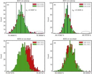
The histograms of the original GPS locations recorded by two seismic stations. The (a) longitude and (b) latitude distributions of station 251 located on an outcrop during the period 2020/01/01–2020/01/30, the black dashed ellipses represent 2.5 standard deviations. The (c) longitude and (d) latitude distributions of station 250 located on the Larsemann Hills ice sheet during 2019/12/06–2019/12/27. The red and green histograms represent the GPS data at the beginning and end of the observation period, respectively.
Credit: ©Science China Press
During the 36th Chinese National Antarctic Research Expedition (CHINARE36) in 2019/2020, we deployed 100 short-period three-component seismometers (SmartSolo-BD3C-5) in the Larsemann Hills, East Antarctica; in addition, 4 short-period seismometers were deployed at Taishan Station. The recording length was approximately one month, and each station recorded more than 4000 GPS location observations while recording seismic data. We found that when the seismic station is located on bedrock, for both longitude (Figure 1a) and latitude (Figure 1b), the distribution characteristics do not change over time. However, when the seismic station is located on an ice sheet, its longitude distribution (Figure 1c) characteristics shift over time, while the latitude distribution (Figure 1d) only slightly changes. This implies that seismic station 250 on the ice sheet moved westward over time.
For seismic station 251 located on bedrock, the GPS location data are divided into five segments at a time interval of 6 days. In Figure 2a, the GPS location coordinates of different time periods are represented by red, green, blue, yellow, and cyan, and the corresponding average value of each segment is represented by a large circle. Theoretically, when the seismic station is located on bedrock, the displacement is zero; however, the calculated maximum displacement in Figure 2a is approximately 0.2 m. Therefore, the error of tracking the ice sheet flow through the position data from the single-mode GPS receiver embedded in the short-period seismograph is approximately 0.2 m/month. Figure 2b shows the GPS position coordinates of seismic station 250 located on the Larsemann Hills ice sheet in different time periods. As time passes, its average position moves approximately 1 m westward.
Based on navigation-grade GPS location data obtained during passive seismic observations during the 36th Chinese National Antarctic Research Expedition, we accurately track the movement characteristics of the ice sheet in the Larsemann Hills (Figure 3) and the Taishan Station area. The ice sheet in the Taishan Station area generally flows westward to the Lambert Glacier Basin. The results from the Taishan Station area are basically the same as those calculated by high-precision geodetic GPS data, indicating that it is feasible to track the movement of the ice sheet using navigation-grade GPS location data logged by short-period seismic stations. The Larsemann Hills ice sheet overall flows westward toward the Polar Record Glacier. During the observation period, the ice sheet displacement varied from 0.5 to 1 m. However, some stations close to the Dalker Glacier are affected by large topographical changes and local stresses, and the direction of ice sheet flow greatly differs. During the one-month passive seismic observation period, the ice sheet in the Taishan Station area and in the Larsemann Hills flowed approximately 1 m; the impact of this movement on seismic observations is negligible. However, if the ice velocity is greater than a few hundred meters or if long-term observations are being recorded, this error may not be negligible.
See the article:
Fu L, Guo J, Chen X. 2021. Measurement of ice flow velocities from GPS positions logged by short-period seismographs in East Antarctica. Science China Earth Sciences, 64(8): 1381–1389, https://doi.org/10.1007/s11430-021-9765-6
Media Contact
All latest news from the category: Earth Sciences
Earth Sciences (also referred to as Geosciences), which deals with basic issues surrounding our planet, plays a vital role in the area of energy and raw materials supply.
Earth Sciences comprises subjects such as geology, geography, geological informatics, paleontology, mineralogy, petrography, crystallography, geophysics, geodesy, glaciology, cartography, photogrammetry, meteorology and seismology, early-warning systems, earthquake research and polar research.
Newest articles

First-of-its-kind study uses remote sensing to monitor plastic debris in rivers and lakes
Remote sensing creates a cost-effective solution to monitoring plastic pollution. A first-of-its-kind study from researchers at the University of Minnesota Twin Cities shows how remote sensing can help monitor and…

Laser-based artificial neuron mimics nerve cell functions at lightning speed
With a processing speed a billion times faster than nature, chip-based laser neuron could help advance AI tasks such as pattern recognition and sequence prediction. Researchers have developed a laser-based…

Optimising the processing of plastic waste
Just one look in the yellow bin reveals a colourful jumble of different types of plastic. However, the purer and more uniform plastic waste is, the easier it is to…


