CALIPSO monitors pulse of Soufriere Hills volcano

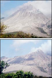
Photo of the growing soufriere Hills Volcano lava dome taken 31 May 2003 <br>Click here for a high resolution photograph.
A unique monitoring system in place on the island of Montserrat can record the everyday changes beneath the Soufriere Hills volcano and throughout the island, according to an international team of volcanologists.
The CALIPSO project (Caribbean Andesite Lava Island Precision Seismo-geodetic Observatory) is the first volcano monitoring system of its type installed at an andesitic volcano. Andesite volcanoes are the most important volcano type making up the Earth’s Ring of Fire, and have caused more fatalities than any other type of volcano. Intended to improve the understanding of how these volcanos erupt, the system investigates the dynamics of the entire magma system below the island.
“We had the system working just in time for the largest lava dome collapse ever seen anywhere,” says Dr. Barry Voight, professor of geosciences at Penn State. “Montserrat is the only place where such an array of monitoring tools, including strain meters, surround the volcano,” he told attendees at the fall meeting of the American Geophysical Conference today (Dec. 16) in San Francisco.
The CALIPSO system features four bore holes, each 600-foot deep and 4.5 inches in diameter through most of its depth. The width of the last 30 feet is a bit narrower to accommodate the equipment, which must be bonded to the surrounding rock. Each bore hole houses a super-sensitive strain meter, a seismometer and a tiltmeter and a geographic positioning system sits above on the ground surface.
“The ground is a 100-times quieter down there than at the surface,” says Voight. “We can record smaller events and deeper events than would be possible on the noisy ground surface, and we can record measurements continuously all day long.”
By comparing the measurements with a computer model of the volcano, the researchers can begin to understand what is happening beneath the surface. The active magma reservoir system may extend to a depth of 10 miles, with its top about 3.5 miles deep. The researchers hope they will be able to measure the position, size and shape of the existing magma reservoir, the quantity of new magma inflow and the physical characteristics of the magma. They also hope to learn more about the earthquake mechanics associated with the dynamic volcanic system.
The institutions involved in the CALIPSO project include Penn State, University of Arkansas, Carnegie Institution of Washington, Duke University, Bristol University (UK), Leeds University (UK), Arizona State University and the Montserrat Volcano Observatory.
Andesitic volcanoes occur throughout the world in such places as Japan, Indonesia, the Andes, the Aleutian Islands and the North American Cascades. They often form lava domes when active. These lava domes can fail, causing either lava block avalanches or violent explosive hurricanes of hot ash and gas that can travel many miles and destroy everything in their paths. These explosive releases cause the most damage to life and property.
The Soufriere Hills Volcano has erupted on and off since July 1995. The latest dome collapse occurred in 2003 and explosions occurred in March and April 2004. Since then the surface activity of the volcano has quieted down, but activity at depth continues, as indicated by the monitoring system. While the volcano has only been active for the past nine years, the island shows a long history of volcanic activity extending back thousands of years.
Now that the CALIPSO equipment is in place, the researchers plan an island-wide experiment using 100 to 150 additional seismographs. From the data collected, the scientists will create a tomographic image of the island similar to PET scans done by hospitals. The scan will show the current and past magma chambers and provide an underground, three-dimensional map of the island and the volcanic system.
Media Contact
More Information:
http://www.psu.eduAll latest news from the category: Earth Sciences
Earth Sciences (also referred to as Geosciences), which deals with basic issues surrounding our planet, plays a vital role in the area of energy and raw materials supply.
Earth Sciences comprises subjects such as geology, geography, geological informatics, paleontology, mineralogy, petrography, crystallography, geophysics, geodesy, glaciology, cartography, photogrammetry, meteorology and seismology, early-warning systems, earthquake research and polar research.
Newest articles

Tackling Life-Threatening Fungal Infections Using RNA Modifications
Importance of RNA modifications for the development of resistance in fungi raises hope for more effective treatment of fungal infections. An often-overlooked mechanism of gene regulation may be involved in…

Unraveling Aphasia: Global Study Breaks Down Patients’ Struggle with Verb Tenses
An international team of researchers, including scientists from the HSE Centre for Language and Brain, has identified the causes of impairments in expressing grammatical tense in people with aphasia. They discovered…

Facing the Storm: A Prepped Up Future Against Extreme Climatic and Weather Changes
From the persistent droughts of southern Africa and Central America in the early part of the year to the more recent devastating extreme rainfall in Spain and the deadly Hurricane…


