Canada’s Shrinking Ice Caps

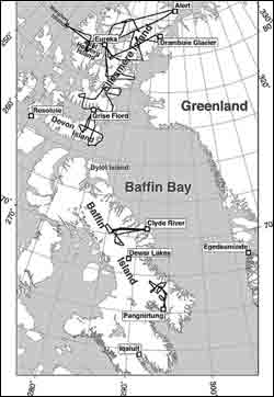
During the research campaigns, first in 1995 and then in 2000, Abdalati and his colleagues flew the NASA P-3 aircraft over the Canada Arctic Archipelago. Shown here is the location map of the 2000 flight lines (repeat surveys of the 1995 lines) where flights were conducted out of Pangnirtung, Clyde River, Grise Fiord, and Eureka. Weather station data used in this analysis were from Eureka, Alert, Resolute, Clyde River, Iqaluit, Egedesminde, and Dewar Lakes. Click on image for a larger view. Image credit: Waleed Abdalati, NASA Goddard Space Flight Center.
Earth’s ice-covered polar regions help to keep our climate cool and hold tremendous amounts of fresh water locked up in their glaciers, ice caps, and ice sheets. The ice contained in these vast freshwater reservoirs is the equivalent of nearly 220 feet of sea level. However, when most people think of polar ice, they usually do not think of Canada, the location of only a small percentage of the Arctic’s polar land ice.
Recent research conducted by NASA scientists has revealed that Canada’s ice caps and glaciers have important connections to Earth’s changing climate, and they have a strong potential for contributing to sea level rise.
Canada’s Arctic region is covered by approximately 150,000 square kilometers (93,205 square miles) of ice. While this land area is tiny compared to Antarctica’s 113.5 million square kilometers (70.5 million square miles), and Greenland’s 1.7 million square kilometers (1.05 million square miles) of ice coverage, it is still quite significant. In the next 100 years, melting glaciers and ice caps outside of Greenland and Antarctica, a significant portion of which includes those in Canada, are expected to raise global sea levels by 20 to 40 centimeters (7.9 to 15.8 inches).
Waleed Abdalati, Head of the Cryospheric Sciences Branch at NASA’s Goddard Space Flight Center (GSFC), Greenbelt, Md. published research recently in the Journal of Geophysical Research showing that Canada’s Arctic ice is one of the more significant and immediate sources of world-wide changes in sea levels.
Abdalati and his colleagues say that Canada’s Arctic ice is important because the wide area covered by these ice caps and the dramatic changes that have taken place in the Arctic climate in recent years. Studying this region will help researchers understand how much and in what ways Arctic glaciers and ice caps are contributing to sea level rise.
“The ice-covered parts of the world, and, in particular, of the Arctic are considered to be very sensitive to change,” said Abdalati.
To study Canada’s ice caps, Abdalati and his colleagues used a laser altimeter mounted on an airplane to measure the precise elevation of the ice surface. By making these measurements over many of the Canadian ice caps once in 1995 and repeating them again in 2000, they were able to determine how much the thickness of the ice sheet changed. By combining this information with temperature and precipitation data from weather stations nearby, and several decades of direct measurement of ice growth and shrinkage on certain ice caps, they were able to put these changes in their appropriate climatological context.
From their research, Abdalati and his colleagues found an increasing trend in both annual temperatures during the second half of the twentieth century. At the same time records showed that accumulation was approximately 15 percent higher during the 1995-2000 time period than for the 1951-1980 period (a data set that is often used as a climatological mean to which new measurements are historically compared). These characteristics contributed to changes in the ice caps in the late 1990s.
The researchers found that in areas where the ice melts very little, there was slight thickening of some ice caps, which could be due to accumulation from increased snowfall; however, overall they found that the ice caps and glaciers were thinning at the lower elevations where melt occurs. In some locations, where the changes were most substantial, this thinning appears to be a continuation of the retreat or melting of glaciers that followed the end of the Little Ice Age — a period 150 years ago when the Earth was cooler and glaciers were more prevalent. However, the researchers also attributed the melting of the ice caps to the short-term warming trend of the late 1990s, which appears to have been amplified in the Arctic. They determined that the ice loss associated with these combined effects contributed to 0.065 millimeters (0.002 inches) per year to sea level rise during the 1995-2000 time period.
“This research is significant because it is the first large-scale assessment of Canada’s ice cap contribution to sea level rise, which has never been put into a comprehensive picture before,” said Abdalati. “The ice caps in the Canadian Arctic are shrinking, and though they are relatively small compared to areas like Greenland and Antarctica, their short-term contributions to sea level cannot be ignored.”
Media Contact
More Information:
http://www.larc.nasa.govAll latest news from the category: Earth Sciences
Earth Sciences (also referred to as Geosciences), which deals with basic issues surrounding our planet, plays a vital role in the area of energy and raw materials supply.
Earth Sciences comprises subjects such as geology, geography, geological informatics, paleontology, mineralogy, petrography, crystallography, geophysics, geodesy, glaciology, cartography, photogrammetry, meteorology and seismology, early-warning systems, earthquake research and polar research.
Newest articles
Humans vs Machines—Who’s Better at Recognizing Speech?
Are humans or machines better at recognizing speech? A new study shows that in noisy conditions, current automatic speech recognition (ASR) systems achieve remarkable accuracy and sometimes even surpass human…

Not Lost in Translation: AI Increases Sign Language Recognition Accuracy
Additional data can help differentiate subtle gestures, hand positions, facial expressions The Complexity of Sign Languages Sign languages have been developed by nations around the world to fit the local…

Breaking the Ice: Glacier Melting Alters Arctic Fjord Ecosystems
The regions of the Arctic are particularly vulnerable to climate change. However, there is a lack of comprehensive scientific information about the environmental changes there. Researchers from the Helmholtz Center…


