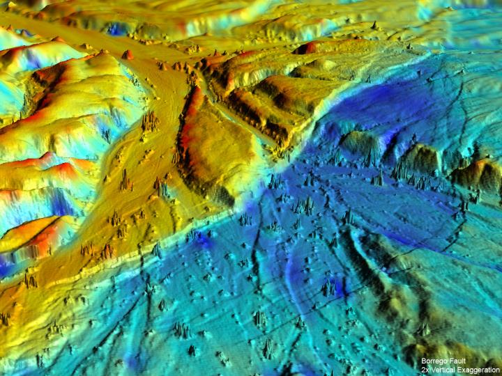

This 3-D LiDAR imaging of the Borrego Fault, ruptured during the 2010 El Mayor-Cucapah earthquake in Baja California, Mexico shows numerous small faults. The various colors represent elevation changes during the earthquake.
Credit: UC Davis
The study, published Feb. 15 in the journal Nature Geoscience, highlights the role of smaller faults in forecasting California's risk of large earthquakes.
In the past 25 years, many of California's biggest earthquakes struck on small faults, away from the San Andreas Fault plate boundary. These events include the Landers, Hector Mine and Napa earthquakes. Several of the quakes were unexpected, rattling areas thought seismically quiet.
A closer look at one of the surprise events, the magnitude-7.2 El Mayor-Cucapah earthquake, showed that small faults may often link together along a “keystone” fault. A keystone is the central stone that holds a masonry structure together. During the El Mayor-Cucapah earthquake, the keystone fault broke first, unlocking seven smaller faults, the study found.
However, the research team discovered that of all the faults unzipped during the El Mayor-Cucapah earthquake, the keystone fault was not the one closest to breaking.
“One of the important outcomes of this study is you can have a whole network of faults activated together by one underpinning fault, and that's an important concern,” said study co-author Michael Oskin, a UC Davis professor of geology. “An earthquake involving a system of small faults can be more damaging than a single event because it increases the amount of seismic energy released.”
HOUSE OF CARDS
The April 4, 2010, El Mayor-Cucapah earthquake leapfrogged across seven faults and jumped a 5-mile wide gap. The researchers used a wealth of recorded seismic data and detailed mapping of surface changes to reconstruct the complex earthquake sequence.
The study reveals the underlying reason for this unusual pattern: a hidden fault buried at a shallow angle to the surface. Each of the seven faults steeply dips toward this hidden fault, linking up deep underground.
Lead author John Fletcher, a professor at CICESE, likened the system to a house of cards — remove one key piece and the entire structure tumbles.
“The trick here is the cards can bend, but it isn't until one particular fault goes that the whole set ruptures,” Fletcher said.
EARTHQUAKE RISK
The El Mayor-Cucapah earthquake occurred in a transition zone, between faults spreading open to form the Gulf of California and faults where the Pacific and North America tectonic plates slip sideways past one another. The earthquake was centered about 30 miles south-southeast of Mexicali in northern Baja California, Mexico.
The results suggest similar processes are at work in other areas where the Earth's crust accommodates major changes in shape.
“This gives us insight into how those messy things between the main faults work,” Oskin said. “This might be pretty common.”
In past events, the signal of a low-angle fault could have been masked because it activated a lot of high-angle faults in the same earthquake, the researchers said.
The idea could also explain a longstanding mystery: why the central San Andreas fault is almost perpendicular to its stress field. Oskin said the central San Andreas fault may also behave like a keystone fault.
###
BACKGROUND
The El Mayor-Cucapah earthquake caused extensive damage to the city of Mexicali, displacing more than 35,000 people and causing two deaths. The shaking demolished roads and irrigation channels in surrounding agricultural areas. Reports documented widespread liquefaction, road ruptures, cracked infrastructure, tilting power line towers and partial or total collapse of many buildings. Damage topped $440 million in the Mexicali Valley and $90 million in California's Imperial Valley.
Orlando Teran, a recent Ph.D. graduate with CICESE also co-authored the report.
The study was funded by the National Council of Science and Technology (CONACYT), National Science Foundation and the Southern California Earthquake Center.


