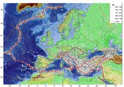
The earthquake risk and Europe

GFZ-EMEC, all earthquakes Mw >3,5 <br>
How strong can earthquakes in Germany be? Where in Europa are the earthquake activities concentrated? These questions are the basis for risk assessments and become relevant when it comes to the safety of buildings or the generation of tsunami.
For the first time, scientists of the GFZ German Research Centre for Geosciences have succeeded in setting up a harmonized catalogue of earthquakes for Europe and the Mediterranean for the last thousand years. This catalogue consists of about 45000 earthquakes, reported in the latest issue of the „Journal of Seismology”.
Earthquakes occur with different frequencies of occurrence, meaning that in some regions, strong earthquakes happen with time gaps of hundreds of years. Such rare events can cause a false feeling of security which belies the true risk. This is compounded by the fact that instrumental measurements only go back for roughly a century, and reliable data for smaller quakes for about half that long.
Thus, the only way to assess the actual risk is the analysis of historical earthquake accounts. „The catalogue that we present here covers the earthquakes of the last thousand years with magnitudes of Mw 3,5 and larger in the northern part of our research area and magnitudes Mw4,0 for the southern part”, explains Dr. Gottfried Grünthal of the GFZ. „Our earthquake catalogue stretches over an area from the Azores to the Caspian Sea and from the Sahara to the North Cape.” Based on some 80 mostly national earthquake catalogues, more than 100 other sources and own analyses of key historical earthquakes, the EMEC-catalogue (European-Mediterranean Earthquake Catalogue) offers the first reliable, regional, long-time database with a harmonized assessment of earthquake magnitudes.
In bringing together all these sources with their considerable differences in magnitude or intensity scales, particular care was taken to harmonize the latter in the form of moment magnitude Mw. The earthquakes in the EMEC are catalogued from 1000 AD bis 2006. In areas south of 40°N and east of 10°E the available data allow for an analysis starting from 300 AD. Of course these data are not complete, especially in the early phase of the catalogued time period.The point in time after which data for certain magnitudes can be assumed as sufficiently complete is very different within the research area. For example, earthquakes with a magnitude of Mw 6,5 and above in the Levant exist more or less completely since 300 AD, and earthquakes of Mw 5 and above since 1965. In Germany, the catalogue of earthquakes with Mw 5 and greater is sufficiently complete since about 1600.
„Part of the EMEC-publication is also a list of so-called fake-quakes, i.e. quakes that have been reported erroneously due to errors of the chroniclers, errors in dates or other mistakes”, explains GFZ scientist Gottfried Grünthal. Importance was also attached to a user-friendly web page: „On the GFZ-EMEC-website, data can be downloaded according to the wishes of the users and epicentre maps can be generated, stored and printed in customized scales of time and space and map projections.”
The EMEC catalogue provides a reliable basis for the risk assessment of earthquakes and quake generated tsunami. Moreover, it is a solid foundation for a whole range of other geoscientific research as well as a source for investigations outside of science.
Pictures in a printable resolution can be found here:
www.gfz-potsdam.de/portal/gfz/Public+Relations/M40-Bildarchiv/Bildergalerie+EMEC
www.gfz-potsdam.de/EMEC
Source: Grünthal G., Wahlström R. (2012) The European-Mediterranean Earthquake Catalogue (EMEC) for the last millennium. Journal of Seismology 16(3): 535-570, DOI: 10.1007/s10950-012-9302-y
Media Contact
More Information:
http://www.gfz-potsdam.deAll latest news from the category: Earth Sciences
Earth Sciences (also referred to as Geosciences), which deals with basic issues surrounding our planet, plays a vital role in the area of energy and raw materials supply.
Earth Sciences comprises subjects such as geology, geography, geological informatics, paleontology, mineralogy, petrography, crystallography, geophysics, geodesy, glaciology, cartography, photogrammetry, meteorology and seismology, early-warning systems, earthquake research and polar research.
Newest articles

Innovative 3D printed scaffolds offer new hope for bone healing
Researchers at the Institute for Bioengineering of Catalonia have developed novel 3D printed PLA-CaP scaffolds that promote blood vessel formation, ensuring better healing and regeneration of bone tissue. Bone is…

The surprising role of gut infection in Alzheimer’s disease
ASU- and Banner Alzheimer’s Institute-led study implicates link between a common virus and the disease, which travels from the gut to the brain and may be a target for antiviral…

Molecular gardening: New enzymes discovered for protein modification pruning
How deubiquitinases USP53 and USP54 cleave long polyubiquitin chains and how the former is linked to liver disease in children. Deubiquitinases (DUBs) are enzymes used by cells to trim protein…


