Errant Galileo satellites will be used for research on Einstein’s general theory of relativity

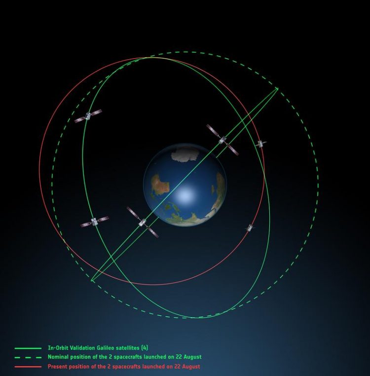
Orbits of the Galileo satellites ESA
“Milena“ and ”Doresa“ were designed to orbit the Earth at a constant height of 23,000 kilometers to deliver precise navigation data for Galileo, the European alternative to the GPS system. However, a frozen fuel line on the launch vehicle caused the satellites to be marooned in an elliptical orbit.
Consequently, their height above the Earth varies continuously between 17,500 and 25,000 kilometers. These fluctuations in height leave them unable to perform their intended task but ideal for the investigation of gravitational red shift, which is one of the central predictions of the general theory of relativity established by Albert Einstein 100 years ago.
This prediction states that gravity – in this case the gravitational force of the Earth – influences time. For example, a clock placed at the top of a tower will run faster than a clock placed at the bottom due to the lower gravitational force it experiences.
The experiment providing the most precise data so far for the proof of the gravitational red shift took place in 1978. Two identical clocks were placed at a distance of 10,000 kilometers – one on Earth and one on a rocket.
In contrast to this one‐off experiment the Galileo satellites change their height by almost 8,000 kilometers twice a day, providing an enormous amount of data. Compared to the experiment in 1978, Laemmerzahl is expecting to show the effect of red shift with 10 times the precision and without the high costs associated with the design of a new research mission.
Contact person for scientific questions:
Prof. Dr. Claus Laemmerzahl
0421 218-57834
claus.laemmerzahl@zarm.uni-bremen.de
Contact person for general press inquiries:
Birgit Kinkeldey
+49 421 218-57755
birgit.kinkeldey@zarm.uni-bremen.de
Photo material concerning the topic can be found under the following link: https://www.zarm.uni-bremen.de/pressmedia/single-view/article/errant-galileo-sat…
Media Contact
All latest news from the category: Earth Sciences
Earth Sciences (also referred to as Geosciences), which deals with basic issues surrounding our planet, plays a vital role in the area of energy and raw materials supply.
Earth Sciences comprises subjects such as geology, geography, geological informatics, paleontology, mineralogy, petrography, crystallography, geophysics, geodesy, glaciology, cartography, photogrammetry, meteorology and seismology, early-warning systems, earthquake research and polar research.
Newest articles

First-of-its-kind study uses remote sensing to monitor plastic debris in rivers and lakes
Remote sensing creates a cost-effective solution to monitoring plastic pollution. A first-of-its-kind study from researchers at the University of Minnesota Twin Cities shows how remote sensing can help monitor and…

Laser-based artificial neuron mimics nerve cell functions at lightning speed
With a processing speed a billion times faster than nature, chip-based laser neuron could help advance AI tasks such as pattern recognition and sequence prediction. Researchers have developed a laser-based…

Optimising the processing of plastic waste
Just one look in the yellow bin reveals a colourful jumble of different types of plastic. However, the purer and more uniform plastic waste is, the easier it is to…


