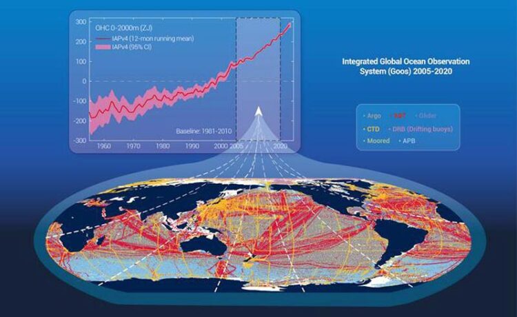
Integrated design of Global Ocean Observing System

Integrated Global Ocean Observation System supports ocean warming monitoring.
Credit: Lijing Cheng
… essential to monitor climate change.
We know that our climate is changing. Extreme weather events are becoming more common, sea levels are rising and overall, our planet is getting warmer. Monitoring these changes is critical. One of the best indicators of climate change is the Ocean Heat Content (OHC) estimate, a measurement of overall oceanic temperature calculated by gathering water temperature data in oceans around the world in differing locations, at varying depths and across time. The data necessary to calculate the OHC over such a wide-spread area is gathered by the Global Ocean Observing System (GOOS), an integrated network of platforms and instrumentation spread out over the world’s oceans. The platforms range from free drifting instrumented floats to instrument packages deployed by research vessels all the way to data loggers attached to pinnipeds such as southern elephant seals. Given the geographical range and technological variety of the GOOS system, and the essential nature of the data being collected, understanding the impact of the differing platforms on the data is essential information.
“However, it is not known the relative contributions of various instrumental systems, i.e. do we just need one system, or do we need all of them?” said Lijing Cheng, the paper’s author, a scientist at the Institute of Atmospheric Physics in Beijing, China. When he looked at the importance of the data gathered from each type of platform on the robustness of the overall OHC estimate Cheng found that “we need an integrated GOOS to fully monitor ocean warming. Different instrumental systems complement each other.”
This study was published on Dec. 20 in Ocean-Land-Atmosphere Research.
Cheng looked at the data gathered from 6 different instrument platforms that constitute GOOS: free drifting instrumented floats (Argos); Mooring and drifting buoys (MRB); Autonomous Pinniped data (APB); the three ship-based instrument platforms, eXpendable BathyThermographs (XBTs), Conductivity-Temperature-Depth (CTD) and gliders (GLD). The sensitivity tests looked at overall OHC data from 2005 to 2020. The data were then compared to new data sets, which were created by removing the data gathered from each individual platform type from the original full data set, one platform at a time. If the data from one platform had a strong impact on the OHC calculations, its removal would result in a very different value for OHC.
“In summary, our sensitivity tests indicate the different impacts of various instrumental platforms on OHC estimates. Argo, CTD, and XBT have near-global impacts, while APB, MRB, and GLD’s impacts are critical in specific regions, which highlights the importance of the GOOS integration function.” said Cheng.
Argos has the greatest coverage of the open ocean, so its importance to the calculation of the OHC estimate is understandable. The CTD and XBT data is collected largely by trained researchers on ships, so it is considered the gold standard for data. Its data set is almost as large as Argos, although its geographical range is smaller.
So why are the other much smaller, more regional platforms useful, such as the pinniped data (APB), the MRB and GLD? These platforms collect data in areas that are not well covered by Argos, which is more focused on the open ocean. The APB data covers areas in the polar regions, the natural habitat of the pinnipeds, the MRB platform gathers data in tropical regions and GLD covers specific coastal areas. These platforms with smaller geographical ranges are necessary to ensure a geographically complete measurement of OHC estimates.
There is more work to be done with GOOS to determine “where are the major data gaps? How to improve the current ocean warming monitoring?” Cheng said, pointing out that future research also needs to look at the effect of the analysis systems that are used to monitor climate change indicators, as “a comprehensive and quantitative assessment of data and methodologies should be part of the evaluation of GOOS, aiming at achieving standard ‘best practices.’”
Research is supported by the National Natural Science Foundation of China, the new Cornerstone Science Foundation through the XPLORER PRIZE, Youth Innovation Promotion Association, Chinese Academy of Sciences; National Key Scientific and Technological Infrastructure project “Earth System Science Numerical Simulator Facility” (EarthLab).
Journal: Ocean-Land-Atmosphere Research
DOI: 10.34133/olar.0037
Method of Research: Observational study
Subject of Research: Not applicable
Article Title: Sensitivity of Ocean Heat Content to Various Instrumental Platforms in Global Ocean Observing System
Article Publication Date: 20-Dec-2023
COI Statement: The authors declare no competing interests.
All latest news from the category: Earth Sciences
Earth Sciences (also referred to as Geosciences), which deals with basic issues surrounding our planet, plays a vital role in the area of energy and raw materials supply.
Earth Sciences comprises subjects such as geology, geography, geological informatics, paleontology, mineralogy, petrography, crystallography, geophysics, geodesy, glaciology, cartography, photogrammetry, meteorology and seismology, early-warning systems, earthquake research and polar research.
Newest articles

Innovative 3D printed scaffolds offer new hope for bone healing
Researchers at the Institute for Bioengineering of Catalonia have developed novel 3D printed PLA-CaP scaffolds that promote blood vessel formation, ensuring better healing and regeneration of bone tissue. Bone is…

The surprising role of gut infection in Alzheimer’s disease
ASU- and Banner Alzheimer’s Institute-led study implicates link between a common virus and the disease, which travels from the gut to the brain and may be a target for antiviral…

Molecular gardening: New enzymes discovered for protein modification pruning
How deubiquitinases USP53 and USP54 cleave long polyubiquitin chains and how the former is linked to liver disease in children. Deubiquitinases (DUBs) are enzymes used by cells to trim protein…


