Linking space observations to ecosystem functions

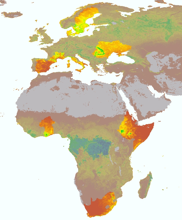
Focus areas in Europe and Africa BACI
Other key elements are, firstly attributing ecosystem transformations to societal transformations, and secondly developing a prototype early warning system for detecting disturbances at the interface of land ecosystems and atmosphere.
The continuous transformation of ecosystems, induced by land use change or resulting from climate change may put at risk the maintenance of regional ecosystem functioning and biodiversity. As promoted by GEO-BON (“The Group On Earth Observations Biodiversity Observation Network”, http://geobon.org/) scientists, land managers, NGOs and policy makers amongst others would benefit tremendously from an easy-to-access system for detecting these changes at an early stage in order to develop mitigation and management strategies.
The new EU-funded BACI project “Detecting changes in essential ecosystem and biodiversity properties – towards a Biosphere Atmosphere Change Index” takes up this challenge and exploits current and future European space data archives, including optical and radar data, to this end.
One component of the international consortium is integration of space and ground data to unravel new and fundamental relationships between space observations and ecosystem status. Modern machine-learning tools will be key to this effort allowing for an effective exploitation of European data and deriving new essential ecosystem variables – in particular, novel “Essential Biodiversity Variables”.
These variables will in turn enable users to more easily interpret observed ecosystem and biodiversity changes. A second component of BACI consists of building a system that auto-matically detects critical transitions in ecosystems and attributes these to transitions in the societal system. One of the goals is identifying hotspots of change within selected key regions in Europe and Africa, all of which are undergoing different societal-ecological transformations that might itself be attributable to environmental change.
The European Horizon 2020 research and innovation programme funds the BACI project which brings together ten leading research and data processing institutions with the intention of contrib-uting to international efforts to advance the monitoring of key properties required to an improved understanding of biodiversity patterns and transformations, as well as to ecosystem functional properties.
The consortium includes the Max Plank Institute for Biogeochemistry (Germany, coordinator), University degli studi della Tuscia (Italy), Eidgenoessische Forschungsanstalt (Switzerland), Friedrich-Schiller-Universität Jena (Germany), Wageningen University (Netherlands), University College London (United Kingdom), Universität Klagenfurt (Austria), Aarhus Universitet (Denmark), Rezatec (United Kingdom) and Science and Technology Facilities Council (United Kingdom).
From May 19 to May 21, 2015 the ten European partners will come together to officially kick off their new project. Besides organizing and hosting the meeting in Jena, the Max Plank Institute for Biogeochemistry is responsible for coordinating, managing, and disseminating the outcome of the project. Within the next four years the scientists will join forces to deliver the first version of an early warning system for ecosystem changes.
Contact:
Dr. Miguel Mahecha
Dpt. Biogeochemical Integration
MPI for Biogeochemistry
07745 Jena, Germany
Ph: 03641-576265
Email: mmahecha@bgc-jena.mpg.de
http://www.baci-h2020.eu project webpage
Media Contact
All latest news from the category: Earth Sciences
Earth Sciences (also referred to as Geosciences), which deals with basic issues surrounding our planet, plays a vital role in the area of energy and raw materials supply.
Earth Sciences comprises subjects such as geology, geography, geological informatics, paleontology, mineralogy, petrography, crystallography, geophysics, geodesy, glaciology, cartography, photogrammetry, meteorology and seismology, early-warning systems, earthquake research and polar research.
Newest articles

First-of-its-kind study uses remote sensing to monitor plastic debris in rivers and lakes
Remote sensing creates a cost-effective solution to monitoring plastic pollution. A first-of-its-kind study from researchers at the University of Minnesota Twin Cities shows how remote sensing can help monitor and…

Laser-based artificial neuron mimics nerve cell functions at lightning speed
With a processing speed a billion times faster than nature, chip-based laser neuron could help advance AI tasks such as pattern recognition and sequence prediction. Researchers have developed a laser-based…

Optimising the processing of plastic waste
Just one look in the yellow bin reveals a colourful jumble of different types of plastic. However, the purer and more uniform plastic waste is, the easier it is to…


