NASA's Aqua Satellite catches brief life of season's first NW Pacific tropical depression

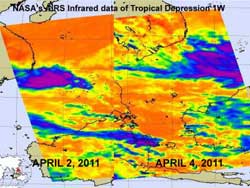
NASA AIRS infrared imagery of TD1W on April 2 shows a more consolidated, rounded and organized tropical depression, whereas the April 4 image shows that wind shear has been tearing the circulation apart and scattering its clouds.<br>Credit: NASA JPL, Ed Olsen
The Northwestern Pacific Ocean basin can experience tropical cyclones almost all year 'round, except that activity is usually minimal in February and March. So, the first tropical cyclone of the new “season” didn't take long to form after the end of March. The Northwestern Pacific includes all of the area north of the equator and west of the International Date Line, including the South China Sea.
The Atmospheric Infrared Sounder (AIRS) instrument that flies aboard NASA's Aqua satellite passed over Tropical Depression 1W (TD1W) on April 2 when it was born, and then again on April 3rd, when it faded. That was a short life for the first tropical depression of the Pacific Northwest's hurricane season, but only the beginning.
AIRS data on April second at 05:41 UTC showed a cluster of strong thunderstorms surrounding the weak center of circulation of TD1W. Some of those thunderstorms were dropping heavy rainfall (about 2 inches / 50 mm per hour) and had very high cloud tops, so high they were as cold as -63 Fahrenheit/-52 Celsius.
On April 2, TD1W was located about 280 miles (450 km) east-southeast of Ho Chi Minh, Vietnam near 9.3 North latitude and 111.2 East longitude. It was moving very slowly at 1 knot (1 mph/2 kmh) to the west and maximum sustained winds were near 25 knots (29 mph/46 kmh).
By April 3 at 0900 UTC it had continued moving slowly, only at a rate of 2 knots (2 mph/4 kmh) westward and was then 315 miles (506 km) east-southeast of Ho Chi Minh, Vietnam near 9.1 North and 111.7 East. It still had maximum sustained winds near 25 knots (29 mph/46 kmh), but wind shear was battering the system.
On April 4 NASA's Aqua satellite passed overhead once again and noticed that TD1W had become much more disorganized and spread out (due to wind shear). By the fourth, TD1W had also moved more than 45 miles farther away from Vietnam and into the South China Sea. Strong convection appeared scattered and disorganized on AIRS' infrared imagery and not around the center of circulation.
Tropical Depression 1W is dissipating in the South China Sea today.
Media Contact
More Information:
http://www.nasa.govAll latest news from the category: Earth Sciences
Earth Sciences (also referred to as Geosciences), which deals with basic issues surrounding our planet, plays a vital role in the area of energy and raw materials supply.
Earth Sciences comprises subjects such as geology, geography, geological informatics, paleontology, mineralogy, petrography, crystallography, geophysics, geodesy, glaciology, cartography, photogrammetry, meteorology and seismology, early-warning systems, earthquake research and polar research.
Newest articles

Innovative 3D printed scaffolds offer new hope for bone healing
Researchers at the Institute for Bioengineering of Catalonia have developed novel 3D printed PLA-CaP scaffolds that promote blood vessel formation, ensuring better healing and regeneration of bone tissue. Bone is…

The surprising role of gut infection in Alzheimer’s disease
ASU- and Banner Alzheimer’s Institute-led study implicates link between a common virus and the disease, which travels from the gut to the brain and may be a target for antiviral…

Molecular gardening: New enzymes discovered for protein modification pruning
How deubiquitinases USP53 and USP54 cleave long polyubiquitin chains and how the former is linked to liver disease in children. Deubiquitinases (DUBs) are enzymes used by cells to trim protein…


