NASA's Aqua satellite sees 3 in 1: Tropical storms Nate, Lee, fires

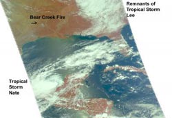
AIRS image on Sept. 8 at 19:05 UTC (3:05 p.m. EDT) shows Tropical Storm Nate along the eastern Mexico coastline, the western edge of the remnants of Tropical Storm Lee in the northern Gulf and smoke plumes in Texas, the largest of which is from the Bear Creek fire. Credit: NASA JPL, Ed Olsen<br>
Nate is one of three major weather events around the Gulf of Mexico today, and NASA's Aqua satellite captured all three in one image. Raging wildfires are occurring in Texas while the remnant clouds from Tropical Storm Lee in the northern Gulf of Mexico were also seen by Aqua.
One satellite image taken by the Atmospheric Infrared Sounder instrument that flies aboard NASA's Aqua satellite captured the two tropical systems and smoke from the Texas fires on Sept. 8 at 19:05 UTC (3:05 p.m. EDT). The image shows Tropical Storm Nate was still lingering along the eastern Mexico coastline, the western edge of the remnants of Tropical Storm Lee (around a low pressure area centered over Indiana) appeared in the northern Gulf and smoke plumes from Texas wildfires. The largest plume appeared light brown in color and was from the Bear Creek fire.
Current forecasts from the National Hurricane Center take Nate on a westward track and away from Texas that would benefit from the rains to combat the wildfires.
A Tropical storm warning is in effect from Chilitepec to Celestun and a Hurricane Watch is in effect from Tampico to Veracruz. A Tropical Storm Watch is in effect from Celestun to Progreso, from Veracruz to Punta El Lagarto, and from Tampico to La Cruz, Mexico.
On Friday, Sept. 9 at 11 a.m. EDT, Tropical Storm Nate was still not moving much in the Bay of Campeche. Nate was crawling to the northwest near 2 mph (4kmh). Nate was centered about 140 miles (225 km) west-northwest of Campeche, Mexico near 20.3 North and 92.6 West. Because tropical-storm-force winds extend 105 miles (165 km) from the center, Campeche is not yet experiencing them. Nate's maximum sustained winds had climbed to 65 mph (100 kmh) and the National Hurricane Center (NHC) expects Nate to reach hurricane status later today or Saturday, Sept. 10. Nate is a compact storm, over 210 miles in diameter.
Tropical Storm conditions are expected in the warning areas today and rainfall from 4 to 6 inches with isolated amounts up to 12 inches are possible over the Mexican states of Campeche and Tabasco, and over southern Veracruz today. Storm surge levels are expected to raise the water levels by 1 to 3 feet along the coast in the warning area.
The NHC is forecasting Nate to become a hurricane and continue moving to the northwest, then turn west and make landfall in Mexico this weekend.
Media Contact
More Information:
http://www.nasa.govAll latest news from the category: Earth Sciences
Earth Sciences (also referred to as Geosciences), which deals with basic issues surrounding our planet, plays a vital role in the area of energy and raw materials supply.
Earth Sciences comprises subjects such as geology, geography, geological informatics, paleontology, mineralogy, petrography, crystallography, geophysics, geodesy, glaciology, cartography, photogrammetry, meteorology and seismology, early-warning systems, earthquake research and polar research.
Newest articles

NASA: Mystery of life’s handedness deepens
The mystery of why life uses molecules with specific orientations has deepened with a NASA-funded discovery that RNA — a key molecule thought to have potentially held the instructions for…

What are the effects of historic lithium mining on water quality?
Study reveals low levels of common contaminants but high levels of other elements in waters associated with an abandoned lithium mine. Lithium ore and mining waste from a historic lithium…

Quantum-inspired design boosts efficiency of heat-to-electricity conversion
Rice engineers take unconventional route to improving thermophotovoltaic systems. Researchers at Rice University have found a new way to improve a key element of thermophotovoltaic (TPV) systems, which convert heat…


