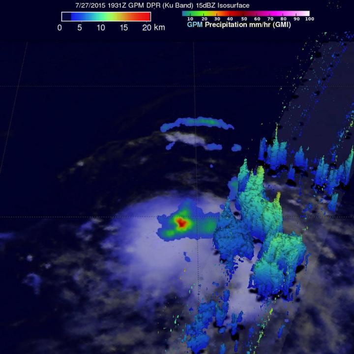
NASA's GPM satellite sees heavy rainfall in new Tropical Depression 8E

On July 27 at 12:31 p.m. PDT, GPM's instruments measured rain falling at a rate of 50 mm (almost 2 inches) per hour (in red) in storms near the center of the tropical depression. Credit: NASA/JAXA/SSAI, Hal Pierce
The GPM core observatory satellite is co-managed by both NASA and the Japan Aerospace Exploration Agency. GPM flew over Tropical Depression 08E (TD08E) when it was forming on July 27, 2015 at 1931 UTC (3:31 p.m. PDT). GPM's Microwave Imager (GMI) and Dual-Frequency Precipitation Radar (DPR) measured rain falling at a rate of 50 mm (almost 2 inches) per hour in storms near the center of tropical depression.
GPM's DPR instrument scan viewed an area east of the center of the developing tropical depression. A simulated 3-D view of storm tops measured by Ku Band radar had reached heights above 14.2 km (8.8 miles). By 5 p.m. EDT, the National Hurricane Center announced that Tropical Depression 8E formed near 15.6 North latitude and 126.1 West longitude.
Twelve hours later at 5 a.m. EDT (0900 UTC) on July 28, the center of Tropical Depression Eight-E was located near latitude 16.2 North, longitude 128.0 West. That puts the center about 1,265 miles (2,035 km) west-southwest of the southern tip of Baja California, Mexico.
The depression was moving toward the west-northwest near 13 mph and is expected to turn west later in the day. Maximum sustained winds were near 35 mph (55 kph) and the depression could become a tropical storm later in the day. The estimated minimum central pressure is 1007 millibars.
National Hurricane Center (NHC) forecaster Cangialosi noted that “The depression is currently experiencing about 15 knots (15.8 mph/27.7 kph) of north-northwesterly shear, which is the reason why most of the thunderstorms are located to the south of the center.”
By July 30, TD08E is expected to move into a more stable air mass and over slightly cooler water, which will prevent the storm from further development.
Media Contact
All latest news from the category: Earth Sciences
Earth Sciences (also referred to as Geosciences), which deals with basic issues surrounding our planet, plays a vital role in the area of energy and raw materials supply.
Earth Sciences comprises subjects such as geology, geography, geological informatics, paleontology, mineralogy, petrography, crystallography, geophysics, geodesy, glaciology, cartography, photogrammetry, meteorology and seismology, early-warning systems, earthquake research and polar research.
Newest articles

First-of-its-kind study uses remote sensing to monitor plastic debris in rivers and lakes
Remote sensing creates a cost-effective solution to monitoring plastic pollution. A first-of-its-kind study from researchers at the University of Minnesota Twin Cities shows how remote sensing can help monitor and…

Laser-based artificial neuron mimics nerve cell functions at lightning speed
With a processing speed a billion times faster than nature, chip-based laser neuron could help advance AI tasks such as pattern recognition and sequence prediction. Researchers have developed a laser-based…

Optimising the processing of plastic waste
Just one look in the yellow bin reveals a colourful jumble of different types of plastic. However, the purer and more uniform plastic waste is, the easier it is to…


