NASA sees Tropical Cyclone Winston U-turn toward Fiji

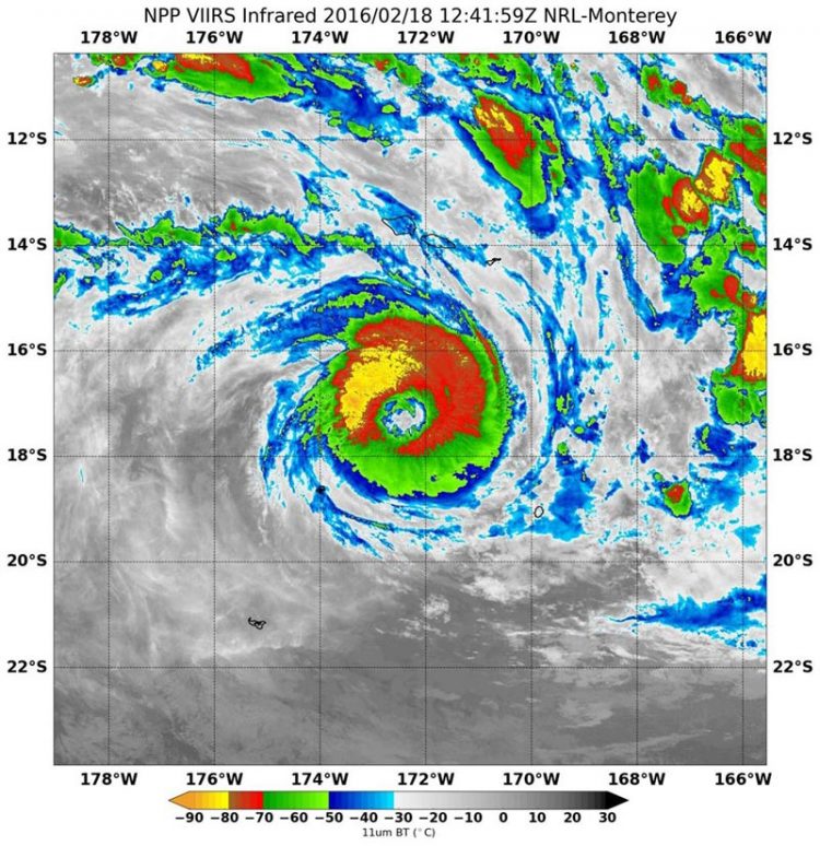
On Feb. 18 at 12:41 UTC (7:41 a.m. EST) NASA-NOAA's Suomi NPP satellite showed Winston had a large eye with tightly curved, strong bands of thunderstorms wrapping into the center. Credits: NASA/NOAA/NRL
On Feb. 18, the gale warning for Niue has been cancelled now that Winston has moved west. However, a tropical cyclone alert is in force for Fiji, specifically the Lau group, Taveuni, Lomaiviti group, eastern half of Viti Levu, Kadavu. In Tonga warnings remain in effect. A storm warning is in effect for Vava'u and a gale warning is in effect for Niuatoputapu, Ha'apai, Tongatapu and 'Eua.
At 1500 UTC (10 a.m. EST) on Feb. 18, Tropical Cyclone Winston's maximum sustained winds were near 100 knots (115.1 mph/185.2 kph). It was a Category 3 hurricane on the Saffir-Simpson Wind Scale, making it a major hurricane. Winston was located near 17.1 degrees south latitude and 172.3 degrees west longitude, about 182 nautical miles northwest of Niue. Winston was moving to the west at 7 knots (8 mph/12.9 kph) and generating wave heights to 28 feet (8.5 meters).
On Feb. 18 at 12:41 UTC (7:41 a.m. EST) NASA-NOAA's Suomi NPP satellite passed over Tropical Cyclone Winston and the Visible Infrared Imaging Radiometer Suite (VIIRS) instrument aboard saw very strong thunderstorms around the eye. Infrared date from VIIRS showed a large eye with tightly curved, strong bands of thunderstorms wrapping into the center. Strongest thunderstorms and coldest cloud tops were in the northwestern quadrant. Temperatures in storms there were as cold as minus 80 degrees Fahrenheit (minus 62.2 Celsius).
Animated enhanced infrared satellite imagery showed that Winston has a large, ragged eye with cloud-top cooling observed within the eye wall over six hours before 1500 UTC. When cloud top temperatures cool it means that the air is rising faster and stronger than before, pushing cloud tops higher into the troposphere (where temperatures are colder). Cooling cloud tops are an indication of a strengthening storm.
The Joint Typhoon Warning Center (JTWC) forecast expects Winston to strengthen to 110 knots (126.6 mph/203.7 kph) and then begin on a weakening trend from Feb. 19 as it tracks over cooler sea surface temperatures. By Feb. 20, Winston is forecast to run into increasing vertical wind shear which will also help to weaken the system.
JTWC calls for Winston to move closest to southern Fiji on Feb. 21. It is then expected to turn southeast. For updated warnings and information from the Fiji Meteorological Service, visit: http://www.
Media Contact
All latest news from the category: Earth Sciences
Earth Sciences (also referred to as Geosciences), which deals with basic issues surrounding our planet, plays a vital role in the area of energy and raw materials supply.
Earth Sciences comprises subjects such as geology, geography, geological informatics, paleontology, mineralogy, petrography, crystallography, geophysics, geodesy, glaciology, cartography, photogrammetry, meteorology and seismology, early-warning systems, earthquake research and polar research.
Newest articles

First-of-its-kind study uses remote sensing to monitor plastic debris in rivers and lakes
Remote sensing creates a cost-effective solution to monitoring plastic pollution. A first-of-its-kind study from researchers at the University of Minnesota Twin Cities shows how remote sensing can help monitor and…

Laser-based artificial neuron mimics nerve cell functions at lightning speed
With a processing speed a billion times faster than nature, chip-based laser neuron could help advance AI tasks such as pattern recognition and sequence prediction. Researchers have developed a laser-based…

Optimising the processing of plastic waste
Just one look in the yellow bin reveals a colourful jumble of different types of plastic. However, the purer and more uniform plastic waste is, the easier it is to…


