New scientific approach assesses land recovery following oil and gas drilling

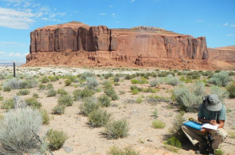
USGS soil scientist Travis Nauman records vegetation data on decommissioned well pad. Credit: USGS
A new scientific approach can now provide regional assessments of land recovery following oil and gas drilling activities, according to a new U.S. Geological Survey study published in the journal Science of the Total Environment.
When developing oil and gas well pads, the vegetation and soil are removed to level the areas for drilling and operations. The new assessment approach, called the disturbance automated reference toolset, or DART, is used to examine recovery patterns after well pads are plugged and abandoned to help resource managers make informed decisions for future well pad development.
“These results may assist land managers in deciding what areas might be best utilized for energy development while also minimizing the long-term environmental impacts,” said Travis Nauman, a USGS scientist and the lead author of the study.
The recovery of well pads following oil and gas development is an area of growing importance because recent technological advances such as hydraulic fracturing and horizontal drilling have initiated rapid increases in development and production. Previous studies estimate that about 11,583 square miles of land in central North America were cleared for oil and gas related purposes between 2000 and 2012.
USGS scientists examined oil and gas well pad recovery on the Colorado Plateau using a new approach that incorporates satellite imagery, digital soil mapping, predictive ecological modeling and field assessments to evaluate vegetation recovery following well pad abandonment. Scientists used DART to study 1,800 well pads in Utah, Colorado and New Mexico. Satellite imagery was used to compare vegetation cover of the abandoned sites to surrounding undisturbed areas with roughly equivalent climate, soil, topography and management histories.
Findings show that most abandoned oil and gas pads in the study are characterized by more bare ground and less vegetation than surrounding undisturbed areas, even after more than 9 years since abandonment. The majority of pads had 15-45 percent increases in bare ground exposure relative to comparable nearby areas. More exposed bare ground makes areas much more susceptible to soil erosion and dust emission.
Differing recovery across environmental gradients and land stewardship suggests that these can be useful for identifying conditions that may promote or hamper pad recovery. Well pads in grasslands, canyon complexes, blackbrush shrublands and shale badlands are not recovering as well as other ecotypes on the Colorado Plateau. Warmer areas with more summer-dominated precipitation were also associated with reduced well pad recovery. Well pads on federally and privately managed lands had the highest recovery index while state-administered lands had the lowest recovery of the ownership entities evaluated. These findings can help managers identify policies or procedures that may lead to improved well pad recovery.
It is still unclear exactly how long well pad disturbances persist on the landscape once well pads are abandoned, particularly in more arid regions like the Southwest, but it may take many years. Active management intervention, or rehabilitation, of vegetation and soils at abandoned well pads has become more common in recent years, but additional work could increase the success of these efforts. New technological advances like DART can help land managers better understand these disturbances by providing timely assessments to help inform management decisions.
Media Contact
All latest news from the category: Earth Sciences
Earth Sciences (also referred to as Geosciences), which deals with basic issues surrounding our planet, plays a vital role in the area of energy and raw materials supply.
Earth Sciences comprises subjects such as geology, geography, geological informatics, paleontology, mineralogy, petrography, crystallography, geophysics, geodesy, glaciology, cartography, photogrammetry, meteorology and seismology, early-warning systems, earthquake research and polar research.
Newest articles

First-of-its-kind study uses remote sensing to monitor plastic debris in rivers and lakes
Remote sensing creates a cost-effective solution to monitoring plastic pollution. A first-of-its-kind study from researchers at the University of Minnesota Twin Cities shows how remote sensing can help monitor and…

Laser-based artificial neuron mimics nerve cell functions at lightning speed
With a processing speed a billion times faster than nature, chip-based laser neuron could help advance AI tasks such as pattern recognition and sequence prediction. Researchers have developed a laser-based…

Optimising the processing of plastic waste
Just one look in the yellow bin reveals a colourful jumble of different types of plastic. However, the purer and more uniform plastic waste is, the easier it is to…


