New technology developed to improve forecasting of Earthquakes, Tsunamis

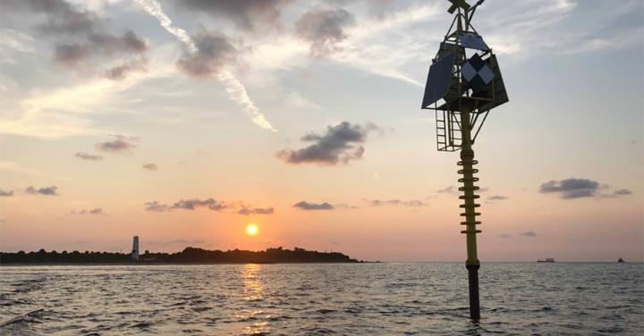
The shallow water buoy can detect small movements and changes in the Earth's seafloor that are often a precursor to deadly natural hazards, like earthquakes, volcanoes and tsunamis. Credit: University of South Florida
University of South Florida geoscientists have successfully developed and tested a new high-tech shallow water buoy that can detect the small movements and changes in the Earth's seafloor that are often a precursor to deadly natural hazards, like earthquakes, volcanoes and tsunamis.
The buoy, created with the assistance of an $822,000 grant from the National Science Foundation's Ocean Technology and Interdisciplinary Coordination program, was installed off Egmont Key in the Gulf of Mexico last year and has been producing data on the three-dimensional motion of the sea floor.
Ultimately the system will be able to detect small changes in the stress and strain the Earth's crust, said USF School of Geosciences Distinguished Professor Tim Dixon.
The patent-pending seafloor geodesy system is an anchored spar buoy topped by high precision Global Positioning System (GPS). The buoy' orientation is measured using a digital compass that provides heading, pitch, and roll information – helping to capture the crucial side-to-side motion of the Earth that can be diagnostic of major tsunami-producing earthquakes, Dixon said.
He was joined in leading the project by USF Geoscience Phd student Surui Xie, Associate Professor Rocco Malservisi USF College of Marine Science's Center for Ocean Technology research faculty member Chad Lembke, and a number of USF ocean technology personnel.
Their findings were recently published in the Journal of Geophysical Research-Solid Earth.
While there are several techniques for seafloor monitoring currently available, that technology typically works best in the deeper ocean where there is less noise interference.
Shallow coastal waters (less than a few hundred meters depth) are a more challenging environment but also an important one for many applications, including certain types of devastating earthquakes, the researchers said. Offshore strain accumulation and release processes are critical for understanding megathrust earthquakes and tsunamis, they noted.
The experimental buoy rests on the sea bottom using a heavy concrete ballast and has been able to withstand several storms, including Hurricane Michael's march up the Gulf of Mexico. The system is capable of detecting movements as small as one to two centimeters, said Dixon, an expert on natural hazards and author of the book Curbing Catastrophe.
“The technology has several potential applications in the offshore oil and gas industry and volcano monitoring in some places, but the big one is for improved forecasting of earthquakes and tsunamis in subduction zones,” Dixon said. “The giant earthquakes and tsunamis in Sumatra in 2004 and in Japan in 2011 are examples of the kind of events we'd like to better understand and forecast in the future.”
Dixon said the system is designed for subduction zone applications in the Pacific Ocean's “Ring of Fire” where offshore strain accumulation and release processes are currently poorly monitored. One example where the group hopes to deploy the new system is the shallow coastal waters of earthquake prone Central America.
The Egmont Key test location sits in just 23 meters depth. While Florida is not prone to earthquakes, the waters off Egmont Key proved an excellent test location for the system. It experiences strong tidal currents that tested the buoy's stability and orientation correction system. The next step in the testing is to deploy a similar system in deeper water of the Gulf of Mexico off Florida's west coast.
###
The deployment of the Egmont Key system was executed in August 2018 in an operation that included teams from the Florida Institute of Oceanography and the R/V Weatherbird II crew, Orion Marine Group, Port Tampa Bay, the Tampa Bay Harbor Pilots Association, Florida Department of Environmental Protection, the U.S. Coast Guard Sector St Pete and District 7 Miami, the Italian Institute of Geophysics and Volcanology (INGV), the non-profit university geosciences consortium UNAVCO, and Hydra Solutions Engineering in Padova, Italy.
The USF team included USF Geosciences Research Assistant Professor Mel Rodgers, and from the USF College of Marine Science Research Associate Jay Law, Electronics Engineer Randy Russell, Associate Professor David Naar, multibeam specialist Jennifer Brizzolara, multibeam sonar specialist John Gray, multibeam scientist Matt Hommeyer and PhD student Jing Chen.
Media Contact
More Information:
http://dx.doi.org/10.1029/2019JB018242All latest news from the category: Earth Sciences
Earth Sciences (also referred to as Geosciences), which deals with basic issues surrounding our planet, plays a vital role in the area of energy and raw materials supply.
Earth Sciences comprises subjects such as geology, geography, geological informatics, paleontology, mineralogy, petrography, crystallography, geophysics, geodesy, glaciology, cartography, photogrammetry, meteorology and seismology, early-warning systems, earthquake research and polar research.
Newest articles

First-of-its-kind study uses remote sensing to monitor plastic debris in rivers and lakes
Remote sensing creates a cost-effective solution to monitoring plastic pollution. A first-of-its-kind study from researchers at the University of Minnesota Twin Cities shows how remote sensing can help monitor and…

Laser-based artificial neuron mimics nerve cell functions at lightning speed
With a processing speed a billion times faster than nature, chip-based laser neuron could help advance AI tasks such as pattern recognition and sequence prediction. Researchers have developed a laser-based…

Optimising the processing of plastic waste
Just one look in the yellow bin reveals a colourful jumble of different types of plastic. However, the purer and more uniform plastic waste is, the easier it is to…


