Earth Sciences (also referred to as Geosciences), which deals with basic issues surrounding our planet, plays a vital role in the area of energy and raw materials supply.
Earth Sciences comprises subjects such as geology, geography, geological informatics, paleontology, mineralogy, petrography, crystallography, geophysics, geodesy, glaciology, cartography, photogrammetry, meteorology and seismology, early-warning systems, earthquake research and polar research.

Currents connecting Pacific and Indian Oceans are colder and deeper than thought
Scientists at Columbia University’s Lamont-Doherty Earth Observatory have found that currents connecting the Indian and Pacific Oceans are colder and deeper than originally believed. This discovery may one day help climate modelers predict the intensity of the Asian monsoon or El Nino with greater accuracy and with more lead-time than is currently possible.
The findings by Arnold Gordon, R. Dwi

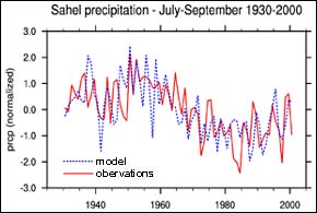
A strong link has been confirmed between sea surface temperatures and precipitation in Africa’s semi-arid Sahel, according to a new study published in Science on October 9th. The study was co-authored by Alessandra Giannini, a climate expert with the International Research Institute for Climate Prediction (IRI), a unit of the Earth Institute at Columbia University.
Previously, it was not known how much land use changes may have led to the region’s recent history of prolonged drought, or whet

A new UK project could help detect evidence for life on Mars, as well as improve our understanding of how it evolved on Earth.
The aim is to develop a technique that can identify biomolecules in water that have been trapped in rocks for millions to billions of years.
As well as analysing samples from Earth, the proposed technique could be used to obtain important information from water sealed within rock samples brought back from Mars, for example. The team will also consider how

NASA’s Ice, Cloud and land Elevation Satellite (ICESat) has resumed measurements of the Earth’s polar ice sheets, clouds, mountains and forests with the second of its three lasers. Crisscrossing the globe at nearly 17,000 miles per hour, this new space mission is providing data with unprecedented accuracy on the critical third dimension of the Earth, its vertical characteristics.
“The first set of laser measurements is revealing features of the polar ice sheets with details never seen befor

NASA researchers and other scientists used a satellite combined with aircraft video to create a new technique for detecting ponds of water on top of Arctic sea ice. Until now, it was not possible to accurately monitor these ponds on ice from space.
Water that forms on sea ice during the summer, called a melt pond, absorbs the Sun’s energy rather than reflecting it back to space the way ice does. The balance between reflected and absorbed energy has a large effect on Arctic and global c

Conventional wisdom says a river’s flood plain builds bit by bit, flood after flood, whenever the stream overflows its banks and deposits new sediment on the flood plain. But for some vast waterways in South America’s Amazon River basin, that wisdom doesn’t hold water, according to scientists funded by the National Science Foundation (NSF). Results of their research are published in the October 2nd issue of the journal Nature. Seasonal rains wash billions of tons of rock and s