Earth Sciences (also referred to as Geosciences), which deals with basic issues surrounding our planet, plays a vital role in the area of energy and raw materials supply.
Earth Sciences comprises subjects such as geology, geography, geological informatics, paleontology, mineralogy, petrography, crystallography, geophysics, geodesy, glaciology, cartography, photogrammetry, meteorology and seismology, early-warning systems, earthquake research and polar research.

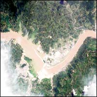
Water churns through diversion holes in the world’s largest dam – China’s Three Gorges project on the Yangtze River, imaged here by ESA’s Proba satellite this week. Seen to the left, the waters behind the dam have risen to a level of 135 metres since the sluice gates were first closed in early June, and in August Three Gorges is due to generate its first commercial hydroelectricity.
The Three Gorges project is set to create a new 600-km-long body of water on the face of the 21st century Ea

The rate at which ozone is being destroyed in the upper stratosphere is slowing, and the levels of ozone-destroying chlorine in that layer of the atmosphere have peaked and are going down — the first clear evidence that a worldwide reduction in chlorofluorocarbon pollution is having the desired effect, according to a new study.
“This is the beginning of a recovery of the ozone layer,” said Professor Michael Newchurch of the University of Alabama in Huntsville (UAH), the scientist wh

At over three thousand metres down in the north-west Indian Ocean, the Carlsberg Ridge is “probably the best ridge in the world”. So say excited scientists from Southampton Oceanography Centre who have just found the first evidence of hydrothermal activity in this previously unexplored area of a volcanic mid-ocean ridge.
The team aboard the research ship RRS Charles Darwin made the discovery on Wednesday 23 July 2003 when they detected a huge plume of smoky water. The plume is at lea

Earth’s youngest desert is shown in this July MERIS satellite image of the Aral Sea in Central Asia. Once the fourth largest lake in the world, over the last 40 years the Aral Sea has evaporated back to half its original surface area and a quarter its initial volume, leaving a 40,000 square kilometre zone of dry white-coloured salt terrain now called the Aralkum Desert.
As its water level has dropped 13 metres since the 1960s the Sea has actually split into two – the larger horseshoe-shaped

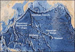
Geologists have long assumed that the Hawaiian Islands owe their existence to a “hotspot” – stationary plumes of magma that rise from the Earth’s mantle to form Mauna Loa, Kilauea and Hawaii’s other massive volcanoes. But a new study posted on the online version of the journal Science disputes that long-standing paradigm by concluding that the fixed hotspot in the Pacific was not stationary after all.
“Our research suggests that the Hawaiian hotspot actually drifted southwa

Scientists from the Lawrence Livermore National Laboratory have determined that human-induced changes in ozone and well-mixed greenhouse gases are the primary drivers of recent changes in the height of the tropopause.
Earlier research has shown that increases in the height of the tropopause over the past two decades are directly linked to stratospheric ozone depletion and increased greenhouse gases.
The new research uses climate model results to provide more quantitative est