Earth Sciences (also referred to as Geosciences), which deals with basic issues surrounding our planet, plays a vital role in the area of energy and raw materials supply.
Earth Sciences comprises subjects such as geology, geography, geological informatics, paleontology, mineralogy, petrography, crystallography, geophysics, geodesy, glaciology, cartography, photogrammetry, meteorology and seismology, early-warning systems, earthquake research and polar research.

How will global warming affect life on Earth? Uncertainties about future climate change and the impact of human activity make it difficult to predict exactly what lies ahead. But the past offers clues, say scientists who are studying a period of warming that occurred about 55 million years ago.
In a joint project of the University of Michigan, the University of New Hampshire and the Smithsonian Institution, researchers have been analyzing fossils from the badlands of Wyoming found in a dist

Highlights, including authors and their institutions
The following highlights summarize research papers in Geophysical Research Letters (GL), Journal of Geophysical Research – Solid Earth (JB), Journal of Geophysical Research – Atmospheres (JD), and Journal of Geophysical Research – Planets (JE). The papers related to these Highlights are printed in the next paper issue of the journal following their electronic publication.
1. Another Great Salinity Anomaly?

Hard-to-detect clouds and water vapor, hidden until now from most atmospheric sensors, could be helping to shape global climate. An instrument package developed by the National Center for Atmospheric Research (NCAR) has detected layers of moisture, indicative of high-level cirrus clouds, that were missed by standard weather balloons and other instruments. The findings are being presented by NCAR scientist Junhong Wang on Tuesday, February 11, in Long Beach, California, at the annual meeting of the Am

Scientists are studying water tables in the Southwest with an eye towards conservation
Scientists have discovered an unusual way to measure how fast water moves from the ground surface to the water table: they analyze the ground temperature.
Research in Vadose Zone Journal, published by the Soil Science Society of America, describes the methodology behind using temperature to analyze how much water is recharging the ground water at a specific location. The research describes

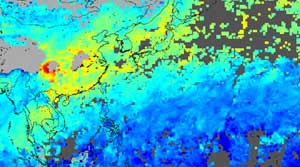
A visualization of satellite data captured and processed January 1–20, 2003, by scientists at the National Center for Atmospheric Research (NCAR) shows heavy pollution from China and Southeast Asia blowing out over the Pacific Ocean. The near-real time capability represented by the image is a breakthrough for NCAR team members working with the Measurements of Pollution in the Troposphere (MOPITT) instrument aboard NASA’s Terra satellite.
The image shows levels of carbon monoxide (CO) in a

The unique capabilities of a NASA earth-observing satellite have allowed researchers to view the effects of a major earthquake that occurred in 2001 in Northern India near the border of Pakistan.
Lead author Bernard Pinty of the Institute for Environment and Sustainability in the Joint Research Centre of the European Commission, Ispra, Italy, and colleagues from the U.S., France and Germany, used the Multi-angle Imaging SpectroRadiometer (MISR) instrument on NASA’s Terra satellite to o