Earth Sciences (also referred to as Geosciences), which deals with basic issues surrounding our planet, plays a vital role in the area of energy and raw materials supply.
Earth Sciences comprises subjects such as geology, geography, geological informatics, paleontology, mineralogy, petrography, crystallography, geophysics, geodesy, glaciology, cartography, photogrammetry, meteorology and seismology, early-warning systems, earthquake research and polar research.

Analysis of long-term changes in Pacific Ocean temperatures may provide additional data with which to evaluate global warming hypotheses.
“Abrupt changes in water temperatures occurring over intervals of up to 25 years suggest that global warming may result as much from natural cyclical climate variations as from human activity,” said Benjamin Giese, oceanography professor in the College of Geosciences.
“Climate models constructed here at Texas A&M University were used to a

Before developers decide to make the desert bloom, they better take a look at what’s under the surface of the Earth.
That’s the conclusion of research by Texas A&M University geologist Mohamed Aly, who’s using GIS (geographic information systems) techniques to conduct engineering geomorphology assessments of some of Egypt’s newest urban developments to predict – and thus avoid – foundation problems stemming from instabilities in the underlying bedrock.
T

Scientists’ understanding of the movement of the Earth’s crust is being helped by new observing facility which is taking measurements that may one day help predict earthquakes.
Newcastle University’s School of Civil Engineering and Geosciences has become only one of two UK centres feeding Global Positioning System (GPS) data into the International GPS Service (IGS), which researchers and professionals throughout the world – including geophysicists – can access via the Internet. The other cen

A new lightning index that uses measurements of water vapor in the atmosphere from Global Positioning Systems has improved lead-time for predicting the first lightning strikes from thunderstorms. The index will help greatly aid NASA Space Shuttle launches at Kennedy Space Center, Fla, and other commercial and U.S. Department of Defense launches from Cape Canaveral Air Force Station, Fla.
“Better forecasting and more advance warning of lightning strikes will help reduce the delays or cancell

Balloons outfitted with innovative steering devices and robot probes could be the future of planetary exploration. Dr. Alexey Pankine, a fellow at the NASA Institute for Advanced Concepts (NIAC), presented an analysis of balloon applications for planetary science at the World Space Congress in Houston, Texas last month. His study, entitled Directed Aerial Robot Explorers or DARE, is funded by NIAC.
At the center of the DARE concept are balloons that can float in planetary atmospheres for man

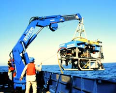
JASON II reaches most of the world ocean floor and sends data ashore via the Internet
A new generation of remotely operated vehicle (ROV) capable of routine operation to depths of 6,500 meters (21,320 feet) and communicating its data back to shore via the Internet has been developed by the Woods Hole Oceanographic Institution (WHOI). The vehicle, JASON II, recently completed its first science cruise off the coast of Washington and Oregon and is currently at sea in the Pacific wo