Receive funding for your R&D Projects!
Your partner for subsidy advice
Your partner for subsidy advice
Earth Sciences (also referred to as Geosciences), which deals with basic issues surrounding our planet, plays a vital role in the area of energy and raw materials supply.
Earth Sciences comprises subjects such as geology, geography, geological informatics, paleontology, mineralogy, petrography, crystallography, geophysics, geodesy, glaciology, cartography, photogrammetry, meteorology and seismology, early-warning systems, earthquake research and polar research.
Scientists at Umeå University in Sweden are putting forward an entirely new picture of climate change and the first immigration of trees following the last Ice Age. Research shows that 8,000-14,000 years ago the climate was considerably warmer than was previously thought. When it was at its warmest 9,000-10,000 years ago, the timberline was 500 m higher than today, and leafy trees grew in the mountains. The spruce immigrated considerably earlier that was assumed until now, and it probably came from t
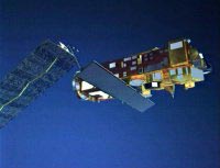
Since its successful launch into sun synchronous orbit on the morning of the first of March, Envisat has been getting ready to start observing the Earth.
Its 70 m2 of solar arrays are fully deployed, thus enabling it to obtain power from the Sun, and the ASAR antenna is now extending to its full 10 m, ready for its deployment in space. This will bring to an end the Launch and Early Orbit Phase.
The next step is the Switch on and Data Acquisition Phase that starts today. One by on
Four years ago, torrential rains battered the Southern US, mudslides struck in Peru – and the inhabitants of Canada`s west coast saved up to 30% on their winter heating bills. The cause? El Niño, a huge temperature shift in the Pacific Ocean which spawns climate changes globally. Today, using satellite Earth observation data, scientists are detecting the early warning signs of a new El Niño event and predicting that it will develop over the next 3 to 6 months, bringing climate changes to countries th
The Scotia Sea, located between the Antarctic and the tip of South America, acts like a ‘blender’ on the very cold ocean waters that influence global ocean circulation patterns and ultimately climate, according to new research from the University of East Anglia (UEA) and published today (28 February) in the international journal Nature.
The research, carried out by Dr Karen Heywood, Dr David Stevens and Dr Alberto Naveira Garabato, shows that the dense, cold waters formed in the Weddell Sea
Europe’s showpiece in climate monitoring is called Envisat. Fully equipped, the largest, most complex, and most powerful Earth observation satellite of the European Space Agency (ESA) is 25 meters high, ten meters wide and weighs over eight tons, scheduled for launch in the night of 28 February /1st March on an Ariane 5 launcher.
Europe’s flying behemoth is on the trail of climate change. It will deliver data about global warming, ozone depletion and climate change for at least five

Satellites see through snow to steer safely across Antarctica.
Satellite images that expose perilous crevasses now reveal safe overland routes to the South Pole. Carolyn Merry of Ohio State University in Columbus has pieced together high-resolution satellite pictures that see through the snow, to map the passable Pole 1 .
Since a snow tractor, floundered into a hidden fissure in 1991, all supplies have been flown into the US South Pole research station. Safe t