NASA scientists take first ’full-body scan’ of evolving thunderstorm

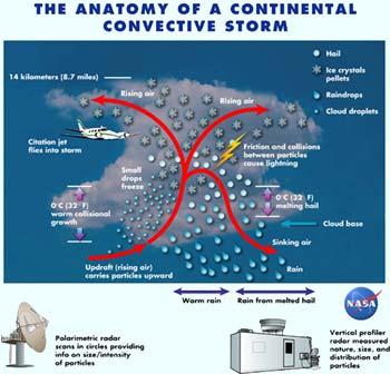
A doctor gets a better view inside a patient by probing the body with CAT and MRI scanning equipment. Now, NASA meteorologists have done a kind of “full-body scan” of an evolving thunderstorm in the tropics, using advanced radar equipment to provide a remarkable picture of the storm’s anatomy. The observations are expected to help double-check satellite rainfall measurements, improve computer models of storms, and make the skies safer for airplanes to navigate.
David Atlas of NASA’s Goddard Space Flight Center, Greenbelt, Md., has gathered the data collected from an unusual storm over the Amazon rainforest in February 1999 and arranged it into an intriguing image of the storm clouds’ inner workings.
The research, co-authored by University of Colorado’s Christopher Williams, appears in the January 2003 American Meteorological Society’s Journal of the Atmospheric Sciences.
Storms often form precipitation in one of two ways, either by forming rain at lower altitudes or by forming frozen particles higher in the atmosphere. But this storm was unusual in that both processes operated as the storm evolved.
In the tropics, the air is warm even at considerably high altitudes, so rain can occur in high clouds by forming liquid droplets without freezing first. During the warm rain stage only the larger drops fall quickly enough to overcome the strength of the updraft, but the smaller ones are carried very high into the clouds, where they freeze into snow and hail. This storm possessed a very strong updraft and also formed frozen precipitation in its upper levels even as rain fell closer to the ground.
“While such a two-phase process should occur in many vigorous storms, it has rarely been observed in a single storm,” Atlas said.
“The ’full-body scan’ also provides new insight into the intensity and hazards within storms, which should be avoided by aircraft. Even the aircraft used in this study did not go into the core of the storm because of the hazards,” Atlas said.
At the higher altitudes, cold temperatures created larger frozen particles that were able to fall through the updraft. The smaller ones continued to rise, colliding with the larger falling ones. These collisions caused friction and electrical charges that generated lightning.
Radar was the primary means by which the “body scan” was taken. A team of scientists from NASA, the National Oceanic and Atmospheric Administration (NOAA), the National Center for Atmospheric Research (NCAR), and other universities used radar equipment sensitive enough to detect the different kinds of particles from the storm’s base up to its top, some 14 km (8.7 miles) above the jungle floor.
Different types of radar examined different aspects of the storm. These included a scanning Doppler radar, often seen on television weather broadcasts, but specially designed with the capability to measure particle types and sizes and rain rates, provided by NCAR; and a vertically oriented Doppler radar, which measures particle motion and size, and vertical air motions, supplied by NOAA. The analysis was also greatly aided by measurements within the storm made by a jet aircraft operated by the University of North Dakota. NASA provided funds for the use of the two radars and the operation of the jet aircraft during this field experiment.”
One purpose of the study was to validate the Tropical Rainfall Measuring Mission (TRMM) satellite measurements. Satellites like TRMM provide data about how these storms operate and help atmospheric scientists better understand how wind circulates above the planet. A continuous array of these evolving tropical thunderstorms around the world acts as a heat engine that warms the upper atmosphere. That warming maintains a gradient of temperature and pressure from the tropics to the poles, and driving the global wind circulation.
“Our particular study attempted to validate what the satellites were showing us with an up-close view,” Atlas said. The validation of TRMM data will help to fine-tune and set the stage for the Global Precipitation Mission (GPM) satellite, which is planned to succeed TRMM.
This research was funded in part by NASA’s Tropical Rainfall Measuring- Mission.
Media Contact
More Information:
http://www.gsfc.nasa.gov/topstory/20021215convective.htmlAll latest news from the category: Earth Sciences
Earth Sciences (also referred to as Geosciences), which deals with basic issues surrounding our planet, plays a vital role in the area of energy and raw materials supply.
Earth Sciences comprises subjects such as geology, geography, geological informatics, paleontology, mineralogy, petrography, crystallography, geophysics, geodesy, glaciology, cartography, photogrammetry, meteorology and seismology, early-warning systems, earthquake research and polar research.
Newest articles

First-of-its-kind study uses remote sensing to monitor plastic debris in rivers and lakes
Remote sensing creates a cost-effective solution to monitoring plastic pollution. A first-of-its-kind study from researchers at the University of Minnesota Twin Cities shows how remote sensing can help monitor and…

Laser-based artificial neuron mimics nerve cell functions at lightning speed
With a processing speed a billion times faster than nature, chip-based laser neuron could help advance AI tasks such as pattern recognition and sequence prediction. Researchers have developed a laser-based…

Optimising the processing of plastic waste
Just one look in the yellow bin reveals a colourful jumble of different types of plastic. However, the purer and more uniform plastic waste is, the easier it is to…


