NASA ties El Niño induced drought to record air pollution from fires

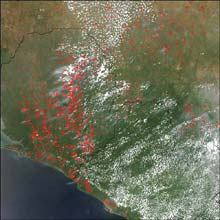
Fires in West Africa The West Africa biomass burning season that began in November 2002 is still underway in late March 2003. This true-color Moderate Resolution Imaging Spectroradiometer (MODIS) image from the Aqua satellite on March 24, 2003, shows scores of fires (in Red) heavily concentrated in Sierra Leone, with other fires scattered across Guinea (top) and Liberia (bottom right). The high-resolution image provided above is 500 meters (3/10ths of a mile) per pixel. CREDIT: Jeff Schmaltz, MODIS Rapid Response Team, NASA GSFC
Scientists using NASA satellite data have found the most intense global pollution from fires occurred during droughts caused by El Niño. The most intense fires took place in 1997-1998 in association with the strongest El Niño event of the 20th century.
Bryan Duncan, Randall Martin, Amanda Staudt, Rosemarie Yevich and Jennifer Logan, from Harvard University, used data observed by NASA’s Total Ozone Mapping Spectrometer (TOMS) satellite to quantify the amount of smoke pollution from biomass burning over 20 years.
“It’s important to study biomass burning, because those fires produce as much pollution as use of fossil fuels. Most of the pollution from fires is produced in the tropics, while pollution from fossil fuel use occurs in North America, Europe and Asia,” Logan said.
One of the missions of NASA’s Earth Science Enterprise, which partially funded the research, is to learn how the Earth system responds to natural and human-induced changes, such as droughts and worldwide fires caused by El Niño. NASA’s Goddard Space Flight Center, Greenbelt, Md, developed the smoke data, the unique Aerosol Index product from the TOMS satellite.
The Harvard scientists recently published a study in the Journal of Geophysical Research Atmospheres that describes how they combined the Aerosol Index data from TOMS with Scanning Radiometer and Sounder (ASTR) fire count data from the European Space Agency’s European Remote Sensing-2 satellite.
The study assessed the effects of the 1997-1998 El Niño events on global biomass burning. They concluded biomass burning around the world was unusually high during the 1997-1998 El Niño, greater than in any other period between 1979 and 2000. The amount of carbon monoxide emitted in 1997 and 1998 was about 30 percent higher than the amount emitted from worldwide motor vehicle and fossil fuel combustion.
“We found that fires typically produce the most pollution in Southeast Asia in March, in northern Africa in January and February, and in southern Africa and Brazil in August and September,” Logan said. During the El Niño of 1997-1998, Indonesia, Mexico, and Central America experienced extreme droughts, and forest fires raged out of control.
The smoke from the fires in Mexico and Central America was blown northward in May 1998, worsening air-quality and reducing visibility over much of the eastern United States. The fires in Indonesia burned tropical forests over an area equivalent to the size of southern New England and released enormous amounts of pollutants. The team estimated the Indonesian fires produced about 170 million metric tons of carbon monoxide, which equals about one-third of the carbon monoxide annually released from fossil fuels.
Biomass burning is the combustion of both living and dead vegetation. It includes fires generated both by lightning and human activity. Humans are responsible for about 90 percent of biomass burning, with only a small percentage of natural fires contributing to the total amount of vegetation burned.
Media Contact
All latest news from the category: Earth Sciences
Earth Sciences (also referred to as Geosciences), which deals with basic issues surrounding our planet, plays a vital role in the area of energy and raw materials supply.
Earth Sciences comprises subjects such as geology, geography, geological informatics, paleontology, mineralogy, petrography, crystallography, geophysics, geodesy, glaciology, cartography, photogrammetry, meteorology and seismology, early-warning systems, earthquake research and polar research.
Newest articles

First-of-its-kind study uses remote sensing to monitor plastic debris in rivers and lakes
Remote sensing creates a cost-effective solution to monitoring plastic pollution. A first-of-its-kind study from researchers at the University of Minnesota Twin Cities shows how remote sensing can help monitor and…

Laser-based artificial neuron mimics nerve cell functions at lightning speed
With a processing speed a billion times faster than nature, chip-based laser neuron could help advance AI tasks such as pattern recognition and sequence prediction. Researchers have developed a laser-based…

Optimising the processing of plastic waste
Just one look in the yellow bin reveals a colourful jumble of different types of plastic. However, the purer and more uniform plastic waste is, the easier it is to…


