New Space-borne Instrument to Track Greenhouse Gases, Ozone Destroyers, and Other Pollutants

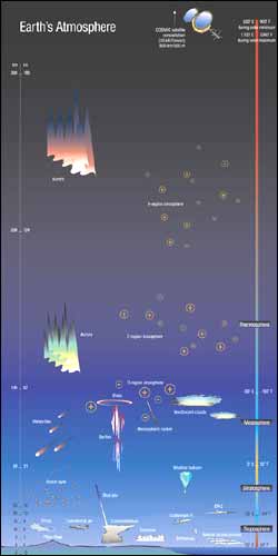
This diagram shows the physical phenomena and observing systems present at various heights in the atmosphere. At left is the height axis (kilometers on the left, miles on the right). At right is the temperature at various heights (Celsius on the left, Fahrenheit on the right). The color of the vertical bar shows cooling as one ascends through the troposphere and warming in an ascent through the stratosphere. High-flying planes are found near the tropopause, the cold, dry boundary region between the troposphere and stratosphere. Ozone is most concentrated in the lower stratosphere (bottom left).
A powerful new instrument heading to space this Saturday is expected to send back long-sought answers about greenhouse gases, atmospheric cleansers and pollutants, and the destruction and recovery of the ozone layer. Only a cubic yard in size but laden with technical wizardry, the High-Resolution Dynamic Limb Sounder (HIRDLS) will measure a slew of atmospheric chemicals at a horizontal and vertical precision unprecedented in a multi-year space instrument.
Scientists at the National Center for Atmospheric Research (NCAR), University of Colorado, and University of Oxford developed HIRDLS (pronounced “hurdles”) with funding from NASA and United Kingdom sources. The U.S. space agency plans to launch the 21-channel radiometer along with three other instruments July 10 aboard its Aura satellite from Vandenberg Air Force Base in California.
HIRDLS will capture the chemistry and dynamics of four layers of the atmosphere that together span a region 8 to 80 kilometers (5 to 50 miles) above Earth’s surface: the upper troposphere, the tropopause, the stratosphere, and the mesosphere.
Using infrared radiation as its yardstick, the radiometer will look through Earth’s atmosphere toward the planet’s limb, or edge. It will find and measure ten different chemical species, characterize airborne particles known as aerosols, and track thin cirrus clouds, all at a vertical resolution of half a kilometer (a third of a mile) and a horizontal resolution of 50 kilometers (30 miles). The signal-to noise ratio is one tenth that of previous detectors.
“The angular resolution of the instrument’s mirror position is equivalent to seeing a dime eight miles away,” says principal investigator John Gille, of NCAR and the University of Colorado.
A few questions HIRDLS data will answer
What are the concentrations of the primary greenhouse gases and their height in the atmosphere? —The answer should reveal where Earth will warm or cool as the global climate changes.
Why does the tropopause exist and what is its role in conveying gases from the troposphere into the stratosphere, especially in the tropics? —Convection was once thought to be the vehicle, but scientists now know warm, rising air normally stops at the frigid, dry tropopause.
Why is the stratosphere, historically dry, now getting wetter? —The answer could shed light on how a changing climate is modifying the atmosphere and how those modifications could in turn feed back into our climate and weather near the ground.
How much ozone is sinking from the stratosphere into the upper troposphere? —The answer will help scientists separate natural ozone pollution from human-made sources and give new information on how the gas is affecting chemistry closer to the ground.
Scientists also expect to see clearly for the first time the dynamic processes that cause water vapor filaments and tendrils to break off and mix with other gases in the troposphere.
Good and bad ozone at different altitudes
At 50 kilometers (30 miles) above the ground, ozone is good: it blocks dangerous ultraviolet radiation and prevents it from harming life and materials at ground level. At 10 kilometers (6 miles), ozone is a greenhouse gas, which is good because the natural greenhouse effect is necessary to warm the planet, but bad if the warming continues to increase at too rapid a rate. At 5 kilometers (3 miles), ozone is a source of the hydroxyl radical, which cleanses the atmosphere of pollutants. But at ground level, ozone is a primary pollutant in smog, causing respiratory problems and damaging trees and crops.
NCAR’s primary sponsor, the National Science Foundation, provided additional support for the research that made HIRDLS possible.
Media Contact
More Information:
http://www.ucar.eduAll latest news from the category: Earth Sciences
Earth Sciences (also referred to as Geosciences), which deals with basic issues surrounding our planet, plays a vital role in the area of energy and raw materials supply.
Earth Sciences comprises subjects such as geology, geography, geological informatics, paleontology, mineralogy, petrography, crystallography, geophysics, geodesy, glaciology, cartography, photogrammetry, meteorology and seismology, early-warning systems, earthquake research and polar research.
Newest articles

First-of-its-kind study uses remote sensing to monitor plastic debris in rivers and lakes
Remote sensing creates a cost-effective solution to monitoring plastic pollution. A first-of-its-kind study from researchers at the University of Minnesota Twin Cities shows how remote sensing can help monitor and…

Laser-based artificial neuron mimics nerve cell functions at lightning speed
With a processing speed a billion times faster than nature, chip-based laser neuron could help advance AI tasks such as pattern recognition and sequence prediction. Researchers have developed a laser-based…

Optimising the processing of plastic waste
Just one look in the yellow bin reveals a colourful jumble of different types of plastic. However, the purer and more uniform plastic waste is, the easier it is to…


