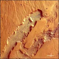
The eroded valleys of Dao and Niger Valles

Colour image of Dao and Niger Valles
These images, taken by the High Resolution Stereo Camera (HRSC) on board ESA’s Mars Express spacecraft, show the Dao Valles and Niger Valles, a system of outflow channels on Mars.
The images were taken during orbit 528 in June 2004, and show the Dao Valles and Niger Valles areas at a point where the north-eastern Hellas impact crater basin and the Hesperia Planum volcanic region meet.
The images are centred at Mars longitude 93° East and latitude 32° South. The image resolution is 40 metres per pixel. The colour image has been created from the HRSC’s nadir (vertical view) and three colour channels. The 3D and the perspective views have been created using the nadir and stereo channels.
The outflow channel system is, in some areas, 40 kilometres wide. The north-eastern ends of the two valleys are almost 200 metres deeper than the south-western regions which are also shown here. The northern Dao Valles, 2400 metres deep, is about 1000 metres deeper than the more southern Niger Valles.
The structure of the valley floor of the Niger Valles is characterised by terraced basins and chaotic fractures. The floor of the Dao Valles is much smoother, but covered with strongly eroded remnants.
These eroded valleys are in a region which is part of the southern flank of the Hadriaca Patera volcano. The surrounding surface is formed by lava streams, probably in a ’runoff’ process.
For more information on Mars Express HRSC images, you might like to read our updated ’Frequently Asked Questions’.
Media Contact
More Information:
http://www.esa.intAll latest news from the category: Earth Sciences
Earth Sciences (also referred to as Geosciences), which deals with basic issues surrounding our planet, plays a vital role in the area of energy and raw materials supply.
Earth Sciences comprises subjects such as geology, geography, geological informatics, paleontology, mineralogy, petrography, crystallography, geophysics, geodesy, glaciology, cartography, photogrammetry, meteorology and seismology, early-warning systems, earthquake research and polar research.
Newest articles

First-of-its-kind study uses remote sensing to monitor plastic debris in rivers and lakes
Remote sensing creates a cost-effective solution to monitoring plastic pollution. A first-of-its-kind study from researchers at the University of Minnesota Twin Cities shows how remote sensing can help monitor and…

Laser-based artificial neuron mimics nerve cell functions at lightning speed
With a processing speed a billion times faster than nature, chip-based laser neuron could help advance AI tasks such as pattern recognition and sequence prediction. Researchers have developed a laser-based…

Optimising the processing of plastic waste
Just one look in the yellow bin reveals a colourful jumble of different types of plastic. However, the purer and more uniform plastic waste is, the easier it is to…


