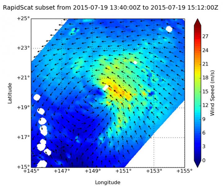
Satellite data shows Tropical Cyclone Halola getting stronger

On July 19, RapidScat saw Halola's strongest sustained winds northeast of the center at 22 meters per second (49.2 mph/79.2 kph). Winds around the rest of the storm were less strong. Credits: NASA JPL, Doug Tyler
On July 19 at 2 p.m. GMT (10 a.m. EDT), the RapidScat instrument aboard the International Space Station gathered data on surface winds in Tropical Depression Halola. RapidScat saw the strongest sustained winds were on the northeastern side as strong as 22 meters per second (49.2 mph/79.2 kph). Winds around the rest of the storm were less strong.
The area of strongest winds appeared to expand on July 20 at 1152 UTC (7:52 a.m. EDT) when the ASCAT-A (Advanced Scatterometer) instrument that flies aboard Europe's EUMETSAT METOP satellite gathered wind data. ASCAT-A showed that Halola's winds were still not symmetrical, but the strongest winds were now along the northern and southeastern edges of the storm.
ASCAT uses radar to measure the electromagnetic backscatter from the wind-roughened ocean surface, from which data on wind speed and direction can be derived. These products are processed by NOAA/NESDIS utilizing measurements from ASCAT.
The Atmospheric Infrared Sounder (AIRS) instrument that flies aboard NASA's Aqua satellite captured infrared data on Halola. AIRS data showed cloud top temperatures were again as cold as -63F/-53C north and east of Tropical Storm Halola's center on July 20 at 3:05 UTC, indicating that there was stronger uplift of air in the storm which can push thunderstorm cloud tops higher in the atmosphere.
NASA research has determined that cloud tops with temperatures near -63 Fahrenheit or -53 Celsius have the ability to generate heavy rainfall (that's over 1 inch or 25 millimeters per hour). When cloud top temperatures are colder than that, the thunderstorms are likely to reach higher in the atmosphere and are likely to be stronger.
Tropical Depression Halola has once again become a tropical storm. At 1500 UTC (11 a.m. EDT), Halola's maximum sustained winds had increased to 50 knots (57.5 mph/92.6 kph). It was centered near 22.0 North latitude and 145.8 East longitude, about 334 nautical miles (384.4 miles/ 618.6 kph) east-southeast of Iwo To island, Japan. Halola has tracked west-northwestward at 12 knots (13.8 mph/22.2 kph).
The Joint Typhoon Warning Center noted that “animated enhanced infrared satellite imagery depicts tight curved banding [of thunderstorms] wrapping around the northern [quadrant] of the cyclone into a well-consolidated low level circulation center.” Microwave data from the METOP-B satellite image showed that an eye was developing.
The Joint Typhoon Warning Center (JTWC) noted that vertical wind shear is easing, and Halola is forecast to move through warm sea surface temperatures allowing for it to strengthen. JTWC calls for Halola to reach typhoon status on Tuesday, July 21 and continue strengthening to 80 knots (92.0 mph/148.2 kph) before weakening on July 24.
###
For more information about how NASA uses infrared light in tropical cyclone research, visit:
http://www.
Media Contact
All latest news from the category: Earth Sciences
Earth Sciences (also referred to as Geosciences), which deals with basic issues surrounding our planet, plays a vital role in the area of energy and raw materials supply.
Earth Sciences comprises subjects such as geology, geography, geological informatics, paleontology, mineralogy, petrography, crystallography, geophysics, geodesy, glaciology, cartography, photogrammetry, meteorology and seismology, early-warning systems, earthquake research and polar research.
Newest articles

An Endless Loop: How Some Bacteria Evolve Along With the Seasons
The longest natural metagenome time series ever collected, with microbes, reveals a startling evolutionary pattern on repeat. A Microbial “Groundhog Year” in Lake Mendota Like Bill Murray in the movie…

Witness Groundbreaking Research on Achilles Tendon Recovery
Achilles tendon injuries are common but challenging to monitor during recovery due to the limitations of current imaging techniques. Researchers, led by Associate Professor Zeng Nan from the International Graduate…

Why Prevention Is Better Than Cure—A Novel Approach to Infectious Disease Outbreaks
Researchers have come up with a new way to identify more infectious variants of viruses or bacteria that start spreading in humans – including those causing flu, COVID, whooping cough…


