Sea level and monsoon

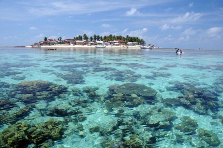
Shallow coral islands like this island in Indonesia's Spermonde Archipelago are particularly exposed to threats from sea level rise and other environmental changes.
Credit: Sebastian Ferse / Leibniz Centre for Tropical Marine Research
How do they influence the development of coral islands?
Coral islands are in danger of slowly sinking in the face of rising sea levels. In a new study, researchers from the Leibniz Centre for Tropical Marine Research (ZMT) found that sea level may not be the only factor playing a role in the fate of threatened islands.
In recent years, alarming reports have accumulated about the slow sinking of coral islands, especially in the Pacific. Tropical coral islands are formed when sediments consisting of calcareous skeletons and shells of corals, clams, snails or calcareous algae are deposited on the roof and in the lagoon of a reef, forming a sandbar. Such islands usually rise only a few meters above sea level. However, due to ocean warming and the melting of the polar ice caps, sea levels could rise by one to two meters by the end of this century. But other environmental factors can also have an impact on coral island development.
To study the dynamics of reef islands over a longer period of time and to better understand changes in their shape, a group of ZMT researchers together with Indonesian colleagues studied the past 10,000 years of geological evolution of a coral island in the Indonesian Spermonde Archipelago: Barrang Lompo.
For this purpose, several ten-meter sediment cores were taken from the island floor. In samples from the cores, the team examined the age, grain size and composition of the sediments from the shells and skeletal fragments of various calcifying organisms. “This allowed us to infer which parts of the reef the organisms came from and how they were transported,” explains Yannis Kappelmann, a geoscientist at ZMT and lead author of the study. The results were then compared with data on sea level trends and climatic conditions over the past 10,000 years.
The team found out that the island formed in a former lagoon surrounded by coral reefs. In a slow process that began 7,000 years ago, waves washed calcareous sediments from the reefs into the lagoon, filling it up until Barrang Lompo Island was formed 3,000 years ago. However, the filling was delayed when the sea level rose by 50 cm above today’s level about 5,800 years ago, as less sediment entered the lagoon.
About 500 years later, the sea level dropped back to its present level. Contrary to the researchers’ expectations, however, the lagoon filled with sediment only unusually slowly thereafter. They attribute this discovery to climatic conditions. The Spermonde Archipelago is a monsoon area, but the strength of the monsoon winds has not always been constant over the last 10,000 years. It was only when the monsoon winds became stronger that the waves again transported sediment into the lagoon.
“Sea level is often used as the only factor to explain the development of coral islands. In the case of Barrang Lompo, however, sea level fluctuations are not sufficient,” says Kappelmann. “If we want to make adequate statements regarding future island developments, we have to include climatic parameters such as wind and other environmental conditions.” So, for example, if monsoon conditions change as a result of climate change, coral islands are likely to change as well.
Indonesia’s Spermonde Archipelago is home to 50,000 people, with 4,600 on Barrang Lompo alone, and studies like this one can help improve future projections for coral islands in the face of global warming and rising sea levels.
Wissenschaftliche Ansprechpartner:
Yannis Kappelmann
Leibniz Centre for Tropical Marine Research (ZMT)
Phone: +49 (0)421 23800 – 93
Mail: yannis.kappelmann@leibniz-zmt.de
Originalpublikation:
Kappelmann, Yannis, Westphal, Hildegard, Kneer, Dominik, Wu, Henry C., Wizemann, Andre, Jompa, Jamaluddin and Mann, Thomas (2023) Fluctuating sea-level and reversing Monsoon winds drive Holocene lagoon infill in Southeast Asia. Scientific Reports, 13 (1). DOI https://doi.org/10.1038/s41598-023-31976-z.
Media Contact
All latest news from the category: Earth Sciences
Earth Sciences (also referred to as Geosciences), which deals with basic issues surrounding our planet, plays a vital role in the area of energy and raw materials supply.
Earth Sciences comprises subjects such as geology, geography, geological informatics, paleontology, mineralogy, petrography, crystallography, geophysics, geodesy, glaciology, cartography, photogrammetry, meteorology and seismology, early-warning systems, earthquake research and polar research.
Newest articles

First-of-its-kind study uses remote sensing to monitor plastic debris in rivers and lakes
Remote sensing creates a cost-effective solution to monitoring plastic pollution. A first-of-its-kind study from researchers at the University of Minnesota Twin Cities shows how remote sensing can help monitor and…

Laser-based artificial neuron mimics nerve cell functions at lightning speed
With a processing speed a billion times faster than nature, chip-based laser neuron could help advance AI tasks such as pattern recognition and sequence prediction. Researchers have developed a laser-based…

Optimising the processing of plastic waste
Just one look in the yellow bin reveals a colourful jumble of different types of plastic. However, the purer and more uniform plastic waste is, the easier it is to…


