Studying landslide’s structure by high-frequency receiver functions of local earthquakes

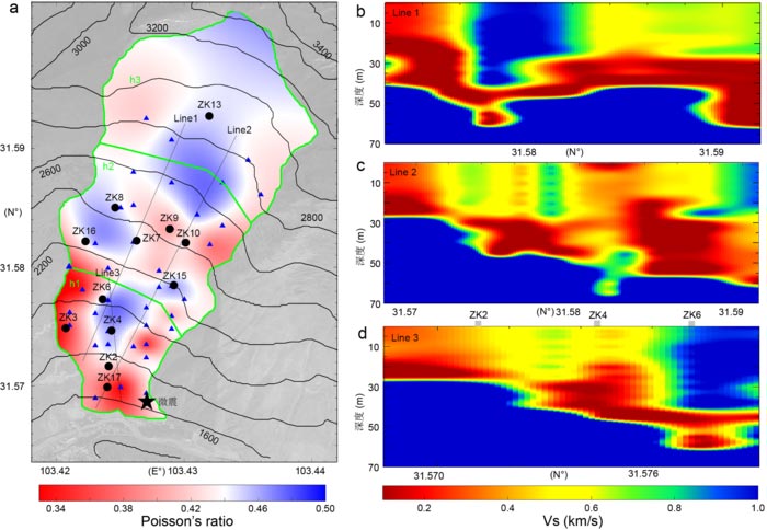
Landslide average Poisson’s ratio (a) and S-wave velocity along typical profiles (b–d). Circles and triangles show the boreholes and seismic stations, respectively.
Credit: ©Science China Press
Landslides are recurrent geological phenomena on Earth that cause heavy casualties and property losses annually. While teleseismic receiver functions have been widely used for crust-mantle structure analysis, they have rarely been employed for inverting shallow structures, mainly because of their lower sensitivity due to Earth’s attenuation of high-frequency waves. Now researchers have pioneered the use of the high-frequency receiver functions of local earthquakes to invert the Poisson’s ratios and shear-wave velocities of the Quaternary Xishancun landslide.
Situated in the town of Tonghua, Li County, Sichuan Province, China, the Xishancun landslide is located in the Longmen Mountains of southwestern China, which is a transitional zone between the Sichuan Basin and the Tibetan Plateau. This zone is characterized by the recurrence of moderate to strong earthquakes related to the uplift of the Tibetan Plateau. The Xishancun landslide is approximately 50 km away from the epicenter of the 2008 MS8.0 Wenchuan earthquake. The deformation of the landslide further escalated after the earthquake, which created several cracks on the landslide surface, as well as severe damage to the residential buildings. The stability and treatment of the Xishancun landslide are urgent for scientific research and engineering tasks.
The researchers firstly carry out a theoretical analysis on the incident angles of the P phases from local earthquakes to the bottom of a landslide layer and use the Haskell method to confirm the synthetics. The theoretical analysis confirm that the incident P phases from local earthquakes fulfill the requirement of near-vertical incident for the Xishancun landslide and suggest the feasibility of extracting high-frequency receiver functions from local earthquakes.
The researches find that, for the Xishancun landslide, the Poisson’s ratio values are generally higher than 0.33 and that the S-wave velocities vary from 0.1 km/s to 0.9 km/s. High Poisson’s ratios of >0.44 are mainly distributed at the juncture regions between different segments, as well as the western edge of h2. These zones show significant variation in landslide thickness and are potentially hazardous areas. Low velocities of 0.05–0.2 km/s with thicknesses of 10–30 m are widely observed in the lower layer of the landslide. The high Poisson’s ratios and low-velocity layer may be related to water-rich materials in these areas.
The study suggests that the high-frequency receiver functions from local earthquakes can be used to delineate geotechnical structures, which is valuable for landslide stability analysis and hazard mitigation.
This research was funded by the Strategic Priority Research Program (B) of Chinese Academy of Sciences (XDB41000000) and the National Science Foundation of China (Grants 41604056, 41661164035).
See the article: Wei Z, Chu R, Li Z, Sheng M, Zeng Q. 2021. Poisson’s ratios and S-wave velocities of the Xishancun landslide, Sichuan, China, inferred from high-frequency receiver functions of local earthquakes. Science China Earth Sciences, 64, https://doi.org/10.1007/s11430-020-9734-5
Journal: Science China Earth Sciences
DOI: 10.1007/s11430-020-9734-5
All latest news from the category: Earth Sciences
Earth Sciences (also referred to as Geosciences), which deals with basic issues surrounding our planet, plays a vital role in the area of energy and raw materials supply.
Earth Sciences comprises subjects such as geology, geography, geological informatics, paleontology, mineralogy, petrography, crystallography, geophysics, geodesy, glaciology, cartography, photogrammetry, meteorology and seismology, early-warning systems, earthquake research and polar research.
Newest articles

First-of-its-kind study uses remote sensing to monitor plastic debris in rivers and lakes
Remote sensing creates a cost-effective solution to monitoring plastic pollution. A first-of-its-kind study from researchers at the University of Minnesota Twin Cities shows how remote sensing can help monitor and…

Laser-based artificial neuron mimics nerve cell functions at lightning speed
With a processing speed a billion times faster than nature, chip-based laser neuron could help advance AI tasks such as pattern recognition and sequence prediction. Researchers have developed a laser-based…

Optimising the processing of plastic waste
Just one look in the yellow bin reveals a colourful jumble of different types of plastic. However, the purer and more uniform plastic waste is, the easier it is to…


