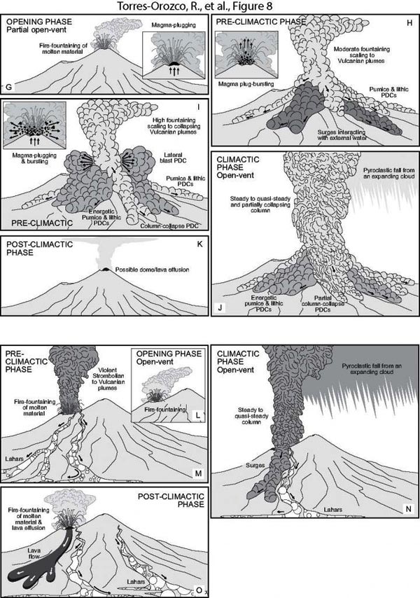

Figure caption: Volcanic hazard scenarios for Plinian eruptions at Mount Taranaki's summit crater and Fanthams Peak vent. A-F: Scenario I. Close-conduits and conduit decompression by vent unroofing and dome collapse. G-K: Scenario II. Transient open and clogged conduits by repeated plugging-and-bursting of gas-depleted or chilled magma. L-O: Scenario III. Rapid progression into steady phases by open conduits. P: Possible upper conduit dynamics for each scenario based on data and interpretations of Torres-Orozco et al. (2017a, 2017b).
Credit: R. Torres-Orozco et al., GSA Bulletin, 2018.
Over the last 5000 years, Mount Taranaki volcano, located in the westernmost part of New Zealand's North Island, produced at least 16 Plinian-scale explosive eruptions, the latest at AD 1655. These eruptions had magnitudes of 4 to 5, eruptive styles, and contrasting basaltic to andesitic chemical compositions comparable to the eruptions of Etna, 122 BC; Vesuvius, AD79; Tarawera, 1886; Pelée, 1902; Colima, 1910; Mount Saint Helens, 1980; Merapi, 2010; and Calbuco, 2015.
In this work, Rafael Torres-Orozco and colleagues combined geological mapping and lithostratigraphic analyses to define the possible hazard scenarios in case of Taranaki's explosive reawakening.
The results indicate that, during a future Plinian event, bursting of both long-lasting, large-volume lava domes and transient, small-volume lava plugs from Taranaki's andesitic summit crater would be typical, and these would produce different types of pyroclastic density currents (PDCs) flowing down the volcano flanks mainly due to gravity.
The most deadly “blast-type” PDCs would first explode and expand laterally, and then would flow downstream, reaching urban areas located at up to 18 km distance from the crater. Eruptive columns following or accompanying PDCs are ubiquitous to every scenario. These columns would inject ash and gas into the atmosphere, and could disperse 10-cm-thick layers of volcanic material over the most populated areas at 20-30 km from the crater. In the scenario of eruptions produced from vents different to the summit-crater, these would be expected to be basaltic and lack major PDCs.
These scenarios highlight the major role that PDCs must have in evaluating the hazardscape of Taranaki and of other similar volcanoes. The scenarios can be tailored to different sites around the world by localized studies, and can also be used to plan emergency management.
###
FEATURED ARTICLE
Volcanic hazard scenarios for multi-phase andesitic Plinian eruptions from lithostratigraphy: Insights into PDC diversity at Mount Taranaki, New Zealand
Author info, CONTACT: Rafael Torres-Orozco, rtofelio@hotmail.com, https:/
GSA BULLETIN articles published ahead of print are online at http://bulletin.


