NASA infrared view finds small areas of strength in new depression 6E

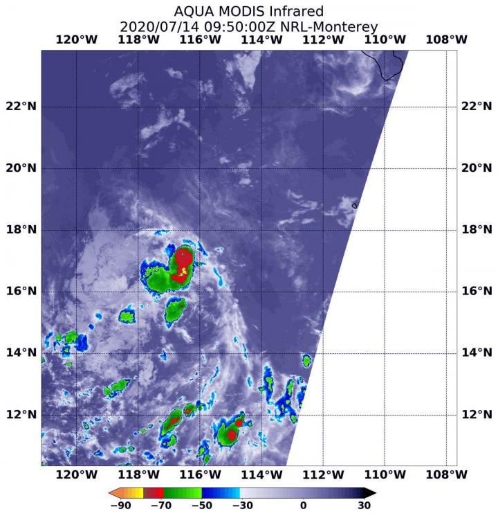
On July 14 at 5:50 a.m. EDT (0950 UTC), the MODIS instrument aboard NASA's Aqua satellite gathered temperature information about Tropical Depression 6E's cloud tops. MODIS found a few small areas of powerful thunderstorms (red) where temperatures were as cold as or colder than minus 70 degrees Fahrenheit (minus 56.6 Celsius). Credit: NASA/NRL
Tropical Depression 6E formed in the Eastern Pacific Ocean by 5 p.m. EDT on July 13 and was located well to the southwest of Baja California Sur, Mexico.
On July 14 at 5:50 a.m. EDT (0950 UTC), the Moderate Resolution Imaging Spectroradiometer or MODIS instrument aboard NASA's Aqua satellite analyzed Tropical Depression 6E's cloud tops in infrared light.
Infrared data provides temperature information, and the strongest thunderstorms that reach high into the atmosphere have the coldest cloud top temperatures.
Aqua found the most powerful thunderstorms in several small, fragmented areas northeast, southeast and southwest of the center of circulation, where temperatures were as cold as or colder than minus 70 degrees Fahrenheit (minus 56.6 Celsius).
Cloud top temperatures that cold indicate strong storms with the potential to generate heavy rainfall. Cloud top temperatures around the rest of the depression were warmer, indicating less-powerful storms.
At 11 a.m. EDT (1500 UTC) on July 14, the NHC said the center of Tropical Depression Six-E was located near latitude 18.1 degrees north and longitude 116.6 degrees west. 6E is far from land areas and is about 545 miles (880 km) southwest of the southern tip of Baja California, Mexico. The depression is moving toward the west-northwest near 16 mph (26 kph).
A faster motion toward the west-northwest or west is expected during the next day or two. The estimated minimum central pressure is 1008 millibars. Maximum sustained winds are near 30 mph (45 kph) with higher gusts. Little change in strength is forecast during the next day or two.
NHC forecaster Robbie Berg noted that, “The depression is forecast to reach waters colder than 26 degrees Celsius (78 degrees Fahrenheit) in 12 to 24 hours, which should extinguish the remaining deep convection.”
Tropical cyclones require sea surface temperatures of at least 26.6 degrees Celsius (80 degrees Fahrenheit) to maintain intensity. Therefore, the depression is expected to become a remnant low or dissipate by early Wednesday.
###
Tropical cyclones/hurricanes are the most powerful weather events on Earth. NASA's expertise in space and scientific exploration contributes to essential services provided to the American people by other federal agencies, such as hurricane weather forecasting.
For updated forecasts, visit: http://www.
By Rob Gutro
NASA's Goddard Space Flight Center
Media Contact
More Information:
https://blogs.nasa.gov/hurricanes/2020/07/14/06e-eastern-pacific-ocean/All latest news from the category: Earth Sciences
Earth Sciences (also referred to as Geosciences), which deals with basic issues surrounding our planet, plays a vital role in the area of energy and raw materials supply.
Earth Sciences comprises subjects such as geology, geography, geological informatics, paleontology, mineralogy, petrography, crystallography, geophysics, geodesy, glaciology, cartography, photogrammetry, meteorology and seismology, early-warning systems, earthquake research and polar research.
Newest articles

Pinpointing hydrogen isotopes in titanium hydride nanofilms
Although it is the smallest and lightest atom, hydrogen can have a big impact by infiltrating other materials and affecting their properties, such as superconductivity and metal-insulator-transitions. Now, researchers from…

A new way of entangling light and sound
For a wide variety of emerging quantum technologies, such as secure quantum communications and quantum computing, quantum entanglement is a prerequisite. Scientists at the Max-Planck-Institute for the Science of Light…

Telescope for NASA’s Roman Mission complete, delivered to Goddard
NASA’s Nancy Grace Roman Space Telescope is one giant step closer to unlocking the mysteries of the universe. The mission has now received its final major delivery: the Optical Telescope…


