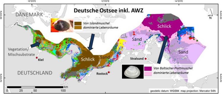
First full-coverage underwater biotope map of the German Baltic Sea developed at IOW

Biotope map after to Schiele et. al. 2015 (detailed key: see original paper): About 20 % of the German Baltic Sea comprises biotopes well worth protecting such as Arctica islandica-dominated muds. IOW
With nine riparian states and about 85 million people living in its catchment area, the Baltic Sea is exposed to an intensive human influence. A key requirement to regulate such an intensive utilisation in a transparent way and without conflict is an internationally harmonised maritime spatial planning (MSP), which regulates the spatial and temporal distribution of human activities at sea.
MSP also plays an essential role in achieving envi-ronmental objectives within binding EU regulations such as the Marine Strategy Framework Directive and Fauna-Flora-Habitat Directive. The effective implementation of these directives requires a sound knowledge of underwater habitats and the occurring species communities.
However, even though the Baltic Sea is one of the best studied regional seas in the world, to-date no large-scale information on the spatial distribution of underwater biotopes has been published for any of its riparian states. The main reason probably is the lack of areal data on underwater species communities as environmental investigations usually are based on point sampling or point observations.
For the German Baltic Sea and the adjacent German exclusive economic zone (EEZ) this knowledge gap has now been closed by a research team headed by IOW marine biologist Kerstin Schiele, who combined the analysis of extensive sample material with novel model-ing techniques to extrapolate point data for the entire study area.
Several thousand samples of benthic organisms were analysed, which had been taken over a 14-year-period (1999 -2013) at more than 2000 sites. The researchers determined the abundance and biomass of macrozoobenthos species – mainly mussels, snails, small crustaceans and marine worms – considered to be character species for certain biotopes.
In a second step, the scientists compiled extensive data sets on abiotic environmental parameters for the study area, such as water depth and temperature, current, salinity, oxygen consumption, and sediment grain-size, by combining data measured at the sampling sites with respective data published in other contexts.
The biological and environmental data were subject to several different computerized analyses a) to identify the occurring biotope types according to the internationally applied HELCOM HUB (H elsinki Com mission U nderwater B iotope and H abitat classification system) and b) to determine the spatial distribution of the biotopes in the study area.
“In total, we identified 68 different HELCOM HUB biotope types. About 20 % of the modeled area comprises Red-listed or other very rare biotopes well worth protecting,” Kerstin Schiele comments on the results. Due to the extensive data sets, the modeling of biotope occurrence and spatial distribution proved to be very successful: For 95 % of the study area the differentiation level necessary for identifying underwater biotopes according to HELCOM HUB was achieved.
“This points to a good applicability of the map as an effective tool for attaining more nature conservation in MSP. The boundaries between underwater biotopes are subject to continuous dynamic change. However, since the new biotope map integrates data from more than 10 years, it provides a good orientation for survey planning to evaluate protection needs of certain areas prior to human intervention,” the marine biologist explains. “Furthermore, the use of an internationally recognized classification system is a good basis for other Baltic Sea states to develop compatible biotope maps,” Schiele concludes.
Generated on behalf of Germany’s Federal Agency for Nature Conservation, the new biotope map was published recently together with the corresponding research in “Marine Pollution Bulletin”: Kerstin S. Schiele, Alexander Darr, Michael L. Zettler, René Friedland, Franz Tauber, Mario von Weber, Joachim Voss (2015) – Biotope map of the German Baltic Sea (doi: 10.1016/j.marpolbul.2015.05.038, http://www.ncbi.nlm.nih.gov/pubmed/26003386).
The study was conducted in cooperation with the State Agency for Environment, Nature Conservation and Geology Mecklenburg-Vorpommern as well as the State Agency for Agri-culture, Environment and Rural Areas Schleswig-Holstein.
*Scientific Contact:
Dr. Kerstin Schiele | IOW working group Ecology of benthic organisms
Phone: +49 (0)381 5197 423 | kerstin.schiele@io-warnemuende.de
*Press and Public Relations at IOW:
Dr. Kristin Beck | Phone: +49 (0)381 – 5197 135 | kristin.beck@io-warnemuende.de
Dr. Barbara Hentzsch | Phone: +49 (0)381 – 5197 102 | barbara.hentzsch@io-warnemuende.de
The IOW is a member of the Leibniz Association with currently 89 research institutes and scientific infrastructure facilities. The focus of the Leibniz Institutes ranges from natural, engineering and environmental sciences to economic, social and space sciences as well as to the humanities. The institutes are jointly financed at the state and national levels. The Leibniz Institutes employ a total of 18.100 people, of whom 9.200 are scientists. The total budget of the institutes is 1.64 billion Euros. (http://www.leibniz-association.eu)
Media Contact
All latest news from the category: Life Sciences and Chemistry
Articles and reports from the Life Sciences and chemistry area deal with applied and basic research into modern biology, chemistry and human medicine.
Valuable information can be found on a range of life sciences fields including bacteriology, biochemistry, bionics, bioinformatics, biophysics, biotechnology, genetics, geobotany, human biology, marine biology, microbiology, molecular biology, cellular biology, zoology, bioinorganic chemistry, microchemistry and environmental chemistry.
Newest articles

First-of-its-kind study uses remote sensing to monitor plastic debris in rivers and lakes
Remote sensing creates a cost-effective solution to monitoring plastic pollution. A first-of-its-kind study from researchers at the University of Minnesota Twin Cities shows how remote sensing can help monitor and…

Laser-based artificial neuron mimics nerve cell functions at lightning speed
With a processing speed a billion times faster than nature, chip-based laser neuron could help advance AI tasks such as pattern recognition and sequence prediction. Researchers have developed a laser-based…

Optimising the processing of plastic waste
Just one look in the yellow bin reveals a colourful jumble of different types of plastic. However, the purer and more uniform plastic waste is, the easier it is to…


