Satellite Time-Lapse Movie Shows California Soaker

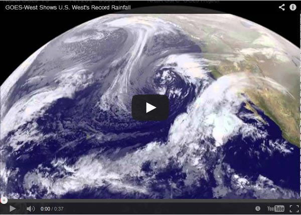
A new time-lapse animation of data from NOAA's GOES-West satellite provides a good picture of why the U.S. West Coast continues to experience record rainfall. The new animation shows the movement of storms from Nov. 30 to Dec. 3. Image Credit: NASA/NOAA GOES Project
NOAA's Geostationary Operational Environmental Satellites or GOES-West imagery from Nov. 30 to Dec. 3 was compiled into a 36 second video made by NASA/NOAA's GOES Project at NASA's Goddard Space Flight Center in Greenbelt, Maryland.
The video shows a low pressure system several hundred miles west of California on Nov. 30. South of the center of the low, a large stream of moisture from the Pacific Ocean was swept up and transported east over the southern part of the state and Baja California, Mexico. Over the course of Dec. 1, 2 and 3 as the low approached the coast the stream of moisture merged with the low, bringing more rains to southern California on Dec. 3.
Water managers are not calling the storm that dropped several inches of rain onto Southern California on Tuesday, Dec. 2, a drought-buster, and climate scientists are not labeling it an El Niño event.
Bill Patzert, climatologist at NASA's Jet Propulsion Laboratory in Pasadena, California who studies ocean patterns, said “scientists have not yet declared an El Niño, and if they do, it would be weak and not necessarily bring torrential rains like in 1997 through 1998, the year that super El Niño' storms drenched Southern California.”
Patzert called the storm a pineapple express of tropical origin that met up with a low-pressure system off the coast. “It is warmer moisture – like a fire hose aimed at us from the south of Hawaii,” Patzert said. “This is an event. It is not a pattern.”
According to the National Weather Service office in Los Angeles, rainfall on Dec. 2 in downtown Los Angeles was 1.21 inches, setting a new record for that date. The previous record was 1.10 inches that fell in 1961. The Los Angeles International Airport recorded a record-breaking 1.12 inches of rainfall on Dec. 2, beating the 1966 record of 0.73 inches.
In Santa Barbara even more rain fell, where a record-breaking total measured was 2.14 inches on Dec. 2. The old record was set in 1966 when 2.12 inches of rain fell. Records were also set on Dec. 2 in Lancaster Fox Field, Calif. with 1.14 inches of rain, Sandberg with 1.49 inches, Palmdale with 1.20 inches, and the Long Beach Airport with 1.04 inches. Further south at Fullerton Airport, a record-setting 0.58 inches fell on Dec. 2.
There is some good news from the rainfall. Patzert pointed to the wetter chaparral in the Southern California foothills “tamping down the prospect of extreme wildfires when the Santa Ana winds are expected to return shortly.” He also pointed up north to snow falling in the Sierra Nevada. Snowpack in that region is where the state gets 95 percent of its water. .
To create the video and imagery, NASA/NOAA's GOES Project takes the cloud data from NOAA's GOES-East satellite and overlays it on a true-color image of land and ocean created by data from the Moderate Resolution Imaging Spectroradiometer, or MODIS, instrument that flies aboard NASA's Aqua and Terra satellites. Together, those data created the entire picture of the storm and show its movement. After the storm system passes, the snow on the ground becomes visible.
GOES satellites provide the kind of continuous monitoring necessary for intensive data analysis. Geostationary describes an orbit in which a satellite is always in the same position with respect to the rotating Earth. This allows GOES to hover continuously over one position on Earth's surface, appearing stationary. As a result, GOES provide a constant vigil for the atmospheric “triggers” for severe weather conditions such as tornadoes, flash floods, hail storms and hurricanes.
For updated information about the storm system, visit NOAA's NWS website: www.weather.gov
For more information about GOES satellites, visit: www.goes.noaa.gov/ or goes.gsfc.nasa.gov/
Rob Gutro
NASA's Goddard Space Flight Center
Media Contact
All latest news from the category: Physics and Astronomy
This area deals with the fundamental laws and building blocks of nature and how they interact, the properties and the behavior of matter, and research into space and time and their structures.
innovations-report provides in-depth reports and articles on subjects such as astrophysics, laser technologies, nuclear, quantum, particle and solid-state physics, nanotechnologies, planetary research and findings (Mars, Venus) and developments related to the Hubble Telescope.
Newest articles

NASA: Mystery of life’s handedness deepens
The mystery of why life uses molecules with specific orientations has deepened with a NASA-funded discovery that RNA — a key molecule thought to have potentially held the instructions for…

What are the effects of historic lithium mining on water quality?
Study reveals low levels of common contaminants but high levels of other elements in waters associated with an abandoned lithium mine. Lithium ore and mining waste from a historic lithium…

Quantum-inspired design boosts efficiency of heat-to-electricity conversion
Rice engineers take unconventional route to improving thermophotovoltaic systems. Researchers at Rice University have found a new way to improve a key element of thermophotovoltaic (TPV) systems, which convert heat…


