Receive funding for your R&D Projects!
Your partner for subsidy advice
Your partner for subsidy advice
Philip Liu, Cornell University professor of civil and environmental engineering, will lead a delegation of American scientists from the National Science Foundation’s Tsunami Research Group and the U.S. Geological Survey (USGS) into the tsunami-ravaged areas of Sri Lanka, Jan. 9-16.
The scientists will examine inundation areas, estimate wave heights, determine the precise arrival time of the tsunami, scour the area for geological evidence and sediment deposits and examine
The newest studies on the Cascadia Subduction Zone off the coast of the Pacific Northwest have identified a “clustering” of great earthquakes of the type that would cause a major tsunami, yielding a historical record with two distinct implications – one that’s good, the other not.
According to scientists at Oregon State University, this subduction zone has just experienced a cluster of four massive earthquakes during the past 1600 years, and if historical trends continue, this cl
Records show an equivalent event on the Oregon coast occurred in 1700
Earthquake-caused tsunamis as severe as those that swept southeast Asia on Sunday have happened in the past off the Oregon coast, according to a University of Oregon geoscientist.
In fact, a tsunami caused by a magnitude 9.0 earthquake occurred on Jan. 26, 1700, wiping out Oregon tribal villages in low-lying coastal estuaries and causing damage as far away as Japan. Ray Weldon, who researches and teac
The type of devastating tsunami that struck the southern coast of Asia is entirely possible in the Pacific Northwest of the United States, but might not cause as much loss of life there because of better warning systems, according to experts at Oregon State University.
OSU is home to the Tsunami Wave Basin at the Hinsdale Wave Research Laboratory, one of the world’s leading research facilities to study tsunamis and understand their behavior, catastrophic effects and possibl
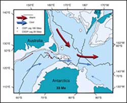
A longstanding theory that provides much of the basis for our understanding of climate change – that the mile-thick ice sheet covering Antarctica developed because of a shift in ocean currents millions of years ago – has been challenged by Purdue University scientists.
Though climate scientists have theorized for decades that the circulation of warm ocean currents was responsible for keeping Antarctica largely ice-free during the Eocene epoch prior to 35 million years ago, a s
There is a desert in the heart of the South Pacific. Surrounding Easter Island is the purest and bluest seawater on Earth, almost empty of the microscopic phytoplankton at the base of the marine food web. French vessel L’Atalante recently completed a research cruise through this region, its day-to-day route guided by ocean colour satellites.
Viewed from orbit, the colour of the global ocean is not constant but varies considerably. Specially built satellite sensors perceive su