Based on 18 months of Envisat observations, this high-resolution global atmospheric map of nitrogen dioxide pollution makes clear just how human activities impact air quality.
ESA’s ten-instrument Envisat, the world’s largest satellite for environmental monitoring, was launched in February 2002. Its onboard Scanning Imaging Absorption Spectrometer for Atmospheric Chartography (SCIAMACHY) instrument records the spectrum of sunlight shining through the atmosphere. These

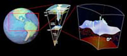
At the surface of Earth, life on a geologic scale is calm and peaceful save the occasional earthquake caused by the rub and slip of Earth’s tectonic plates. But below Earth’s surface, scientists are beginning to find a far more dynamic and tumultuous region than previously thought.
Deep inside Earth, where the mantle meets the molten iron core, researchers are finding telltale signs of what could be a highly active area filled with exotic forms and substances. “This layer is far
Historical study shows elevated aridity in periods of warming
Severe drought in western states in recent years may be linked to climate warming trends, according to new research led by scientists from the Lamont-Doherty Earth Observatory of Columbia University to be posted October 7 on Science magazine’s website, www.sciencemag.org. This research was supported by the National Oceanic and Atmospheric Administration (NOAA) and the National Science Foundation (NSF).
While Antarctica has mostly cooled over the last 30 years, the trend is likely to rapidly reverse, according to a computer model study by NASA researchers. The study indicates the South Polar Region is expected to warm during the next 50 years.
Findings from the study, conducted by researchers Drew Shindell and Gavin Schmidt of NASA’s Goddard Institute of Space Studies (GISS), New York, appeared in the Geophysical Research Letters. Shindell and Schmidt found depleted ozone leve
Researchers at the University of Colorado at Boulder have found that the extent of Arctic sea ice, the floating mass of ice that covers the Arctic Ocean, is continuing its rapid decline.
The latest satellite information indicates the September 2004 sea ice extent was 13.4 percent below average, a reduction in area nearly twice the size of Texas, said Mark Serreze of CU-Boulder’s National Snow and Ice Data Center, or NSIDC. In 2002, the decline in arctic sea ice during Septemb
Why is it that all the volcanic activity in the United States is targeted in the Northwest? Could such activity that we are now witnessing with Mount St. Helens in Washington happen on the East Coast?
That isn’t likely to happen anytime soon–even by geological standards–since the geological conditions on the East Coast lack key conditions necessary for volcanic activity, says R.J. Tracy, professor of geosciences at Virginia Tech.
According to Tracy, the following c