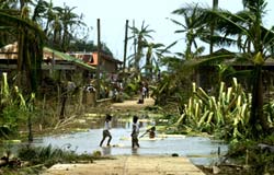
The 150-kilometre-per-hour winds of Typhoon Nida brought destruction and death to the Philippines this week. At least 31 people were killed and hundreds more were made homeless as the storm passed across the eastern part of the country on Wednesday.
Envisat acquired this image of the eye of the Typhoon on Tuesday 18 May, using its Medium Resolution Imaging Spectrometer (MERIS) in reduced resolution mode. The 1200-metre resolution image is some 1150 km wide.
The storm caused floods

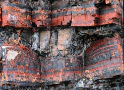
NASA and the United States Geological Survey (USGS) are teaming up to create one of the most complete databases of magnetic properties of Earth’s rocks ever assembled. The partnership demonstrates ongoing interagency collaboration.
Satellite data of Earth’s magnetic field combined with rock magnetic data collected on the ground will provide more complete insight into Earth’s geology, gravity and magnetism.
Satellites, including NASA’s Magsat, have detected magnetic signals in the

Data from NASA’s Terra satellite is adding to our understanding of how pollution spreads around the globe. The information will help scientists protect and understand the Earth.
NASA funded scientists from the National Center for Atmospheric Research (NCAR), Boulder, Colo., will present two studies focusing on global air pollution. Their presentations are part of the 2004 Joint Assembly of the American and Canadian Geophysical Unions.
David Edwards will discuss “Observations
How dolphins evolved to fly like birds under water
Physicists in Japan have discovered how the surface of a dolphin’s skin reduces drag and helps them glide smoothly and quickly through water. These findings could help scientists design faster, energy-efficient boats, ocean liners, and submarines. This research is published in the Institute of Physics journal, Journal of Turbulence.
Scientists have known for some time that dolphins have evolved streamlined bodies which
In an experiment that demonstrates how maps of the genetic codes of simpler organisms can shed light on human disease, a computerized comparison of the complete genetic codes of a type of algae, a weed and humans has led medical researchers to a gene linked to a human illness.
The comparison allowed researchers at Washington University School of Medicine in St. Louis to locate human genes that code for proteins likely to become part of hair-like structures on cells known as cilia or flagel

The most northerly active volcano on Russia’s Kamchatka Peninsula is once again erupting, dusting the surrounding snow-white landscape with a wide expanse of dark ash that is visible from 800 km away in space.
This image of the Kamchatka Peninsula on Russia’s East Coast was acquired on 11 May 2004 by the Medium Resolution Imaging Spectrometer (MERIS) instrument on ESA’s Envisat satellite in reduced resolution mode.
Two thirds of the way up the Peninsula can be seen