A New Tool to Help Keep Roads Ice- and Snow-Free

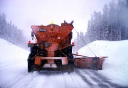
Plowing and other winter-weather road treatment should become more efficient and effective through the MDSS system. (Photo courtesy UCAR/NCAR/NSF.) <br>
Testing Begins This Winter
The National Center for Atmospheric Research (NCAR) and the Federal Highway Administration (FHWA) are testing a Web-based system for weather forecasting and winter road treatment that could soon save lives, cut costs, and help keep millions of drivers on the move. Highway officials and road crews in Des Moines and Ames, Iowa, will test the Maintenance Decision Support System (MDSS) February 3 to April 4.
Motor vehicle accidents involving bad weather (largely ice and snow) claim the lives of more than 6,000 Americans and injure almost half a million people each year. Nearly half of the nation’s state transportation departments have already signed on as stakeholders in the MDSS (see “On the Web” below), along with more than a dozen private firms. The latter are considering developing products and services around the core capabilities of the system.
The MDSS will help agencies better gauge where and when to use road treatments. This means providing more than a generic outlook such as “snow likely tonight,” according to NCAR scientist William Mahoney, who is overseeing the development of the MDSS. “We need forecasts that are more specific, more timely, and tailored for decision makers who are not meteorologists.”
Currently there is no national standard for linking weather outlooks to road conditions. Pavement can freeze or thaw in minutes over small areas, and it’s difficult for road crews to handle all of these variations efficiently. The FHWA launched an initiative to address these and other weather-related hazards in 2000, choosing NCAR as the project leader because of its experience in developing short-range, fine-scale computer models and decision support tools.
To develop a prototype, NCAR has been working with the U.S. Army’s Cold Regions Research and Engineering Laboratory, the National Oceanic and Atmospheric Administration’s Forecast Systems Laboratory, and the Massachusetts Institute of Technology’s Lincoln Laboratory. The end result pulls together existing road and weather data to create a user-friendly picture.
The MDSS uses several computer models to project hour-by-hour weather and road conditions up to two days in advance, with an update every three hours. The system will allow its users to
- view predicted weather and road conditions
- monitor the potential for deteriorating road conditions
- predict the impact of upcoming weather on specific road segments
- assess treatment recommendations based on proven rules of practice
- devise a plan for anti-icing, deicing, plowing, or other road treatment
In short, says Mahoney, “Users can pick a route, look at conditions, see what would happen if they didn’t take any action, and ask the system for a recommended treatment.” According to FHWA administrator Mary Peters, “Having access to proper weather and road condition information before and during adverse winter weather conditions will help transportation system managers take appropriate measures to make keep roads open. MDSS will help make roads safer.” The system is also expected to save money and help the environment by fine-tuning the amount of chemicals needed to treat roads. In addition, it will help state agencies identify windows of good weather for highway repair and maintenance.
Three state-run maintenance garages serving highways across central Iowa will put MDSS through its paces this winter. Each plowing route’s predominant characteristics, such as pavement type, will be specified in advance. With such detail in hand, the system can assess how temperature combined with snow or ice will affect the road surface. Ultimately, users will be able to ask the system to track features as specific as a single bridge paved in concrete along an asphalt road. Using the MDSS display interface and an Internet connection, anyone interested will be able to view a portion of the real-time displays being used in the Iowa simulations.
Contact:
Anatta
UCAR Communications
Telephone: (303) 497-8604
E-mail: anatta@ucar.edu
Bill Outlaw
Federal Highway Administration
Telephone: (202) 366-0660
E-mail: William.Outlaw@fhwa.dot.gov
Media Contact
More Information:
http://www.ucar.edu/communications/newsreleases/2003/mdss.htmlAll latest news from the category: Transportation and Logistics
This field deals with all spatial and time-related activities involved in bridging the gap between goods and people, including their restructuring. This begins with the supplier and follows each stage of the operational value chain to product delivery and concludes with product disposal and recycling.
innovations-report provides informative reports and articles on such topics as traffic telematics, toll collection, traffic management systems, route planning, high-speed rail (Transrapid), traffic infrastructures, air safety, transport technologies, transport logistics, production logistics and mobility.
Newest articles

First-of-its-kind study uses remote sensing to monitor plastic debris in rivers and lakes
Remote sensing creates a cost-effective solution to monitoring plastic pollution. A first-of-its-kind study from researchers at the University of Minnesota Twin Cities shows how remote sensing can help monitor and…

Laser-based artificial neuron mimics nerve cell functions at lightning speed
With a processing speed a billion times faster than nature, chip-based laser neuron could help advance AI tasks such as pattern recognition and sequence prediction. Researchers have developed a laser-based…

Optimising the processing of plastic waste
Just one look in the yellow bin reveals a colourful jumble of different types of plastic. However, the purer and more uniform plastic waste is, the easier it is to…


